IMAGES TAKEN NEAR TO
Northampton Road, NORTHAMPTON, NN6 0HE
Introduction
This page details the photographs taken nearby to Northampton Road, NN6 0HE by members of the Geograph project.
The Geograph project started in 2005 with the aim of publishing, organising and preserving representative images for every square kilometre of Great Britain, Ireland and the Isle of Man.

There are currently over 7.5m images from over14,400 individuals and you can help contribute to the project by visiting https://www.geograph.org.uk
Image Map
Images are licensed for reuse under creativecommons.org/licenses/by-sa/2.0
Notes
- Clicking on the map will re-center to the selected point.
- The higher the marker number, the further away the image location is from the centre of the postcode.
Image Listing (18 Images Found)
Images are licensed for reuse under creativecommons.org/licenses/by-sa/2.0
Image
Details
Distance
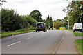

7
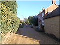
Leys Road
Houses in Earls Barton.
Image: © Burgess Von Thunen
Taken: 26 Oct 2015
0.19 miles
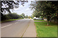
8
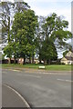
Trees on the green at the end of Elizabeth Way
Image: © Philip Jeffrey
Taken: 28 Apr 2019
0.20 miles
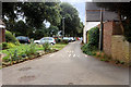
9
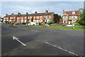
Terraced houses on the edge of Earls Barton
Image: © Philip Jeffrey
Taken: 28 Apr 2019
0.20 miles
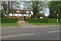
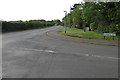
10
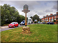
Earls Barton Village Sign, Northampton Road
Image: © David Dixon
Taken: 6 Sep 2016
0.21 miles