IMAGES TAKEN NEAR TO
Park Walk, NORTHAMPTON, NN5 7LG
Introduction
This page details the photographs taken nearby to Park Walk, NN5 7LG by members of the Geograph project.
The Geograph project started in 2005 with the aim of publishing, organising and preserving representative images for every square kilometre of Great Britain, Ireland and the Isle of Man.

There are currently over 7.5m images from over14,400 individuals and you can help contribute to the project by visiting https://www.geograph.org.uk
Image Map
Images are licensed for reuse under creativecommons.org/licenses/by-sa/2.0
Notes
- Clicking on the map will re-center to the selected point.
- The higher the marker number, the further away the image location is from the centre of the postcode.
Image Listing (16 Images Found)
Images are licensed for reuse under creativecommons.org/licenses/by-sa/2.0
Image
Details
Distance
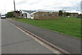
1
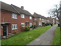
South Oval
1950s council houses in Kings Heath.
Image: © Burgess Von Thunen
Taken: 6 Nov 2014
0.04 miles
2
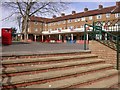
Park Square, King's Heath
The main shopping centre.
Image: © Kokai
Taken: 12 Oct 2006
0.07 miles
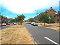
3
Park Drive, King's Heath
Taken from near the roundabout on Mill Lane and Park Drive.
Image: © Kokai
Taken: 12 Oct 2006
0.07 miles
4
Derwent Drive
1950s council houses in Kings Heath.
Image: © Burgess Von Thunen
Taken: 14 Nov 2014
0.08 miles

7
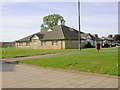
King's Heath Community Centre
Situated in the corner of a park and also includes the Housing Office and Healthcare Centre.
Image: © Kokai
Taken: 12 Oct 2006
0.11 miles
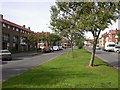
8
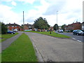
Park Drive, King's Heath, Northampton
Park Drive is one of the main routes for traffic into and out of the King's Heath estate, on the outskirts of Northampton.
Image: © Malc McDonald
Taken: 28 Jul 2018
0.15 miles
9
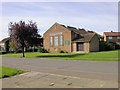
The Parish Church of St Augustine
Seen across Medway Drive.
Image: © Kokai
Taken: 12 Oct 2006
0.15 miles
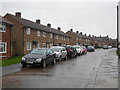
10
Severn Drive
1950s council houses in Kings Heath.
Image: © Burgess Von Thunen
Taken: 18 Aug 2014
0.18 miles