IMAGES TAKEN NEAR TO
Bourne Crescent, NORTHAMPTON, NN5 7JD
Introduction
This page details the photographs taken nearby to Bourne Crescent, NN5 7JD by members of the Geograph project.
The Geograph project started in 2005 with the aim of publishing, organising and preserving representative images for every square kilometre of Great Britain, Ireland and the Isle of Man.

There are currently over 7.5m images from over14,400 individuals and you can help contribute to the project by visiting https://www.geograph.org.uk
Image Map (Loading...)


Getting Data...Please wait
Leaflet Map data © OpenStreetMap
Images are licensed for reuse under creativecommons.org/licenses/by-sa/2.0
Notes
- Clicking on the map will re-center to the selected point.
- The higher the marker number, the further away the image location is from the centre of the postcode.
Image Listing (12 Images Found)
Images are licensed for reuse under creativecommons.org/licenses/by-sa/2.0
Image
Details
Distance
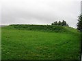
1
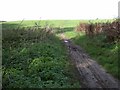
Footpath across the Heath
One of two trods I saw into the area which are neither signposted nor marked on the OS map.
Image: © Kokai
Taken: 12 Oct 2006
0.05 miles
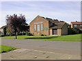
5
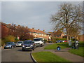
West Oval
1950s council houses in Kings Heath.
Image: © Burgess Von Thunen
Taken: 6 Nov 2014
0.15 miles
7
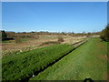
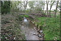
Dallington Brook
Alongside Brookside Meadows.
Image: © Burgess Von Thunen
Taken: 23 Mar 2014
0.17 miles
9
The Parish Church of St Augustine
Seen across Medway Drive.
Image: © Kokai
Taken: 12 Oct 2006
0.22 miles