IMAGES TAKEN NEAR TO
Gladstone Road, NORTHAMPTON, NN5 7EJ
Introduction
This page details the photographs taken nearby to Gladstone Road, NN5 7EJ by members of the Geograph project.
The Geograph project started in 2005 with the aim of publishing, organising and preserving representative images for every square kilometre of Great Britain, Ireland and the Isle of Man.

There are currently over 7.5m images from over14,400 individuals and you can help contribute to the project by visiting https://www.geograph.org.uk
Image Map
Images are licensed for reuse under creativecommons.org/licenses/by-sa/2.0
Notes
- Clicking on the map will re-center to the selected point.
- The higher the marker number, the further away the image location is from the centre of the postcode.
Image Listing (11 Images Found)
Images are licensed for reuse under creativecommons.org/licenses/by-sa/2.0
Image
Details
Distance
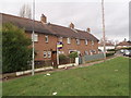
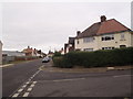
2
Tintern Avenue
1950s council houses in Spencer.
Image: © Burgess Von Thunen
Taken: 29 Sep 2015
0.12 miles
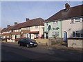
3
Pembroke Road
Vehicle maintenance in Spencer.
Image: © Burgess Von Thunen
Taken: 30 Sep 2014
0.18 miles
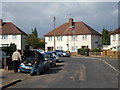
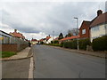
4
Swansea Road
If you look carefully you can see a human in one of the front gardens.
Image: © Burgess Von Thunen
Taken: 5 Feb 2016
0.20 miles
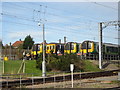
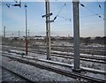
6
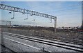
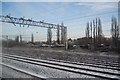
Railway sidings, north of Northampton Station
Image: © N Chadwick
Taken: 19 Dec 2010
0.21 miles
8
Countess Road
1930s council houses in St James.
Image: © Burgess Von Thunen
Taken: 26 Mar 2014
0.21 miles
10
Countess Road
1930s council houses in Spencer.
Image: © Burgess Von Thunen
Taken: 5 Feb 2016
0.22 miles