IMAGES TAKEN NEAR TO
Harlestone Road, NORTHAMPTON, NN5 7AF
Introduction
This page details the photographs taken nearby to Harlestone Road, NN5 7AF by members of the Geograph project.
The Geograph project started in 2005 with the aim of publishing, organising and preserving representative images for every square kilometre of Great Britain, Ireland and the Isle of Man.

There are currently over 7.5m images from over14,400 individuals and you can help contribute to the project by visiting https://www.geograph.org.uk
Image Map
Images are licensed for reuse under creativecommons.org/licenses/by-sa/2.0
Notes
- Clicking on the map will re-center to the selected point.
- The higher the marker number, the further away the image location is from the centre of the postcode.
Image Listing (16 Images Found)
Images are licensed for reuse under creativecommons.org/licenses/by-sa/2.0
Image
Details
Distance
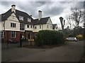
1
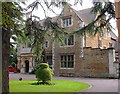
Templemore and the Cedars Care Home for the Elderly
This was originally built as Templemore - a convalescent home.
Image: © Kokai
Taken: 12 Oct 2006
0.05 miles
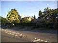
2
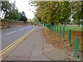
Dallington Park Road
Seen from near Harlestone Road.
Image: © Kokai
Taken: 12 Oct 2006
0.07 miles
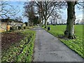
3
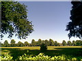
Dallington Park
Over the wall from Harlestone Road.
Image: © Burgess Von Thunen
Taken: 17 Jun 2010
0.08 miles
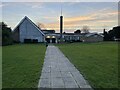
5
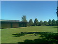
Dallington Park
Next to the disused changing rooms.
Image: © Burgess Von Thunen
Taken: 17 Jun 2010
0.12 miles
6
Avalon
A big house made into smaller houses.
Image: © Burgess Von Thunen
Taken: 5 Apr 2019
0.13 miles
7
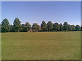
Dallington Park
A 23-acre park gifted to the corporation in 1921 by the Lewis family.
Image: © Burgess Von Thunen
Taken: 17 Jun 2010
0.17 miles
8
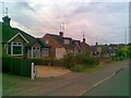
Bants Lane
1950s bungalows in Duston.
Image: © Burgess Von Thunen
Taken: 20 Jul 2010
0.18 miles