IMAGES TAKEN NEAR TO
Eastfield Road, NORTHAMPTON, NN5 6TQ
Introduction
This page details the photographs taken nearby to Eastfield Road, NN5 6TQ by members of the Geograph project.
The Geograph project started in 2005 with the aim of publishing, organising and preserving representative images for every square kilometre of Great Britain, Ireland and the Isle of Man.

There are currently over 7.5m images from over14,400 individuals and you can help contribute to the project by visiting https://www.geograph.org.uk
Image Map (Loading...)


Getting Data...Please wait
Leaflet Map data © OpenStreetMap
Images are licensed for reuse under creativecommons.org/licenses/by-sa/2.0
Notes
- Clicking on the map will re-center to the selected point.
- The higher the marker number, the further away the image location is from the centre of the postcode.
Image Listing (7 Images Found)
Images are licensed for reuse under creativecommons.org/licenses/by-sa/2.0
Image
Details
Distance
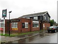
2
Houses on Main Road
Looking from Malpas Road junction.
Image: © Oast House Archive
Taken: 1 Jul 2011
0.13 miles
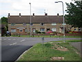
4

Kerrfield Estate
1930s council semis in Duston.
Image: © Burgess Von Thunen
Taken: 4 Nov 2016
0.23 miles
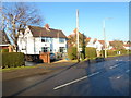
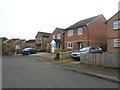
5

Beaufort Drive
1980s houses in Duston.
Image: © Burgess Von Thunen
Taken: 2 Feb 2016
0.24 miles
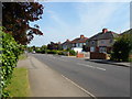
6
Main Road
1930s houses in Duston.
Image: © Burgess Von Thunen
Taken: 9 Feb 2015
0.25 miles
7
Beaufort Drive
1980s houses in Duston.
Image: © Burgess Von Thunen
Taken: 19 Jan 2015
0.25 miles