IMAGES TAKEN NEAR TO
Oakleigh Drive, NORTHAMPTON, NN5 6RP
Introduction
This page details the photographs taken nearby to Oakleigh Drive, NN5 6RP by members of the Geograph project.
The Geograph project started in 2005 with the aim of publishing, organising and preserving representative images for every square kilometre of Great Britain, Ireland and the Isle of Man.

There are currently over 7.5m images from over14,400 individuals and you can help contribute to the project by visiting https://www.geograph.org.uk
Image Map
Images are licensed for reuse under creativecommons.org/licenses/by-sa/2.0
Notes
- Clicking on the map will re-center to the selected point.
- The higher the marker number, the further away the image location is from the centre of the postcode.
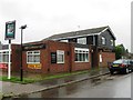
Image Listing (5 Images Found)
Images are licensed for reuse under creativecommons.org/licenses/by-sa/2.0
Image
Details
Distance
1
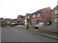
Beaufort Drive
1980s houses in Duston.
Image: © Burgess Von Thunen
Taken: 19 Jan 2015
0.05 miles
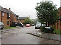
2

Beaufort Drive
1980s houses in Duston.
Image: © Burgess Von Thunen
Taken: 2 Feb 2016
0.06 miles
5
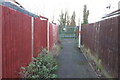
Almost a path onto Harlestone Road
But the gate is padlocked with anti climb paint and barbed wire
Image: © Philip Jeffrey
Taken: 9 Jan 2022
0.22 miles