IMAGES TAKEN NEAR TO
Avignon Close, NORTHAMPTON, NN5 6QS
Introduction
This page details the photographs taken nearby to Avignon Close, NN5 6QS by members of the Geograph project.
The Geograph project started in 2005 with the aim of publishing, organising and preserving representative images for every square kilometre of Great Britain, Ireland and the Isle of Man.

There are currently over 7.5m images from over14,400 individuals and you can help contribute to the project by visiting https://www.geograph.org.uk
Image Map (Loading...)


Getting Data...Please wait
Leaflet Map data © OpenStreetMap
Images are licensed for reuse under creativecommons.org/licenses/by-sa/2.0
Notes
- Clicking on the map will re-center to the selected point.
- The higher the marker number, the further away the image location is from the centre of the postcode.
Image Listing (13 Images Found)
Images are licensed for reuse under creativecommons.org/licenses/by-sa/2.0
Image
Details
Distance
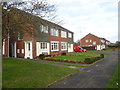
1
Footpath alongside Sandy Lane
A housing estate is behind the hedge on the left. A little further on the path emerges from behind the hedge on the right to become a normal footpath on the side of the road.
Image: © Kokai
Taken: 12 Oct 2006
0.15 miles
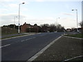
2
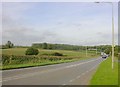
Sandy Lane
Now a busy road joining the A4500 to the south, but here running between housing and farmland.
Image: © Kokai
Taken: 12 Oct 2006
0.16 miles
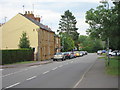
3
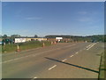
Sandy Lane
Looking a bit different to Image They're gonna blast a by-pass through the countryside. Nice.
Image: © Burgess Von Thunen
Taken: 19 Jul 2010
0.18 miles
4
Park Lane
1970s maisonettes in Duston.
Image: © Burgess Von Thunen
Taken: 5 Dec 2014
0.20 miles
6
Weggs Farm Road
Into New Duston.
Image: © Burgess Von Thunen
Taken: 23 Feb 2012
0.21 miles
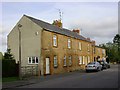
8
Port Road
Stone cottages in New Duston.
Image: © Burgess Von Thunen
Taken: 5 Sep 2013
0.21 miles
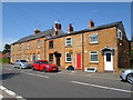
9
Duston Wildes
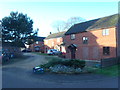
1990s houses in Duston.
Image: © Burgess Von Thunen
Taken: 31 Dec 2015
0.22 miles
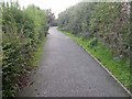
10
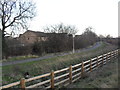
Sandy Lane
The old road, now a cyclepath.
Image: © Burgess Von Thunen
Taken: 23 Feb 2012
0.22 miles