IMAGES TAKEN NEAR TO
Larch Lane, NORTHAMPTON, NN5 6NP
Introduction
This page details the photographs taken nearby to Larch Lane, NN5 6NP by members of the Geograph project.
The Geograph project started in 2005 with the aim of publishing, organising and preserving representative images for every square kilometre of Great Britain, Ireland and the Isle of Man.

There are currently over 7.5m images from over14,400 individuals and you can help contribute to the project by visiting https://www.geograph.org.uk
Image Map
Images are licensed for reuse under creativecommons.org/licenses/by-sa/2.0
Notes
- Clicking on the map will re-center to the selected point.
- The higher the marker number, the further away the image location is from the centre of the postcode.
Image Listing (13 Images Found)
Images are licensed for reuse under creativecommons.org/licenses/by-sa/2.0
Image
Details
Distance
1
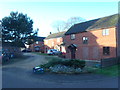
Duston Wildes
1990s houses in Duston.
Image: © Burgess Von Thunen
Taken: 31 Dec 2015
0.05 miles
2
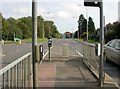
Harlestone Road (A428)
View towards Northampton from a traffic island near the end of Quarry Road.
Image: © Kokai
Taken: 12 Oct 2006
0.10 miles
3
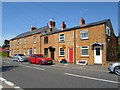
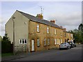
Port Road
Stone cottages in New Duston.
Image: © Burgess Von Thunen
Taken: 5 Sep 2013
0.11 miles
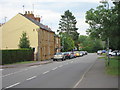
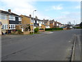
6

Bretton Close
1950s bungalows in Duston.
Image: © Burgess Von Thunen
Taken: 2 Feb 2016
0.12 miles
7
Grafton Way
1970s semis in Duston.
Image: © Burgess Von Thunen
Taken: 1 Apr 2014
0.14 miles
8
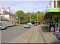
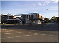
Shopping Centre on Quarry Road
The Rifle Butt public house is seen across the road on the corner with Harlestone Road.
Image: © Kokai
Taken: 12 Oct 2006
0.14 miles
9
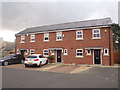
Harlestone Road
2010s houses in Duston.
Image: © Burgess Von Thunen
Taken: 16 Nov 2015
0.14 miles
10
Shops on the corner of Harlestone Road, New Duston
Image: © David Howard
Taken: 21 May 2017
0.15 miles