IMAGES TAKEN NEAR TO
Aquitaine Close, NORTHAMPTON, NN5 6EP
Introduction
This page details the photographs taken nearby to Aquitaine Close, NN5 6EP by members of the Geograph project.
The Geograph project started in 2005 with the aim of publishing, organising and preserving representative images for every square kilometre of Great Britain, Ireland and the Isle of Man.

There are currently over 7.5m images from over14,400 individuals and you can help contribute to the project by visiting https://www.geograph.org.uk
Image Map
Images are licensed for reuse under creativecommons.org/licenses/by-sa/2.0
Notes
- Clicking on the map will re-center to the selected point.
- The higher the marker number, the further away the image location is from the centre of the postcode.
Image Listing (8 Images Found)
Images are licensed for reuse under creativecommons.org/licenses/by-sa/2.0
Image
Details
Distance
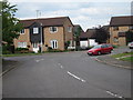
1
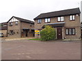
Aquitane Close
1980s houses in St Giles Park.
Image: © Burgess Von Thunen
Taken: 15 Sep 2015
0.03 miles
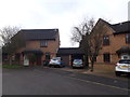
2
Bollinger Close
1980s houses in New Duston.
Image: © Burgess Von Thunen
Taken: 10 Mar 2014
0.05 miles
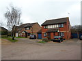
3
Weggs Farm Road
1990s houses in St Giles Park.
Image: © Burgess Von Thunen
Taken: 22 Dec 2015
0.06 miles
4
Bordeaux Close
1990s houses in Alsace Park.
Image: © Burgess Von Thunen
Taken: 22 Dec 2015
0.08 miles
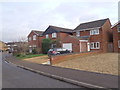
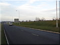
5
Weggs Farm Road
Looking from Malpas Road junction.
Image: © Oast House Archive
Taken: 1 Jul 2011
0.11 miles
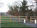
6
Sandy Lane
New road on the edge of Duston.
Image: © Burgess Von Thunen
Taken: 23 Feb 2012
0.17 miles
7
Sandy Lane
The old road, now a cycle path.
Image: © Burgess Von Thunen
Taken: 23 Feb 2012
0.19 miles
8
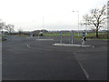
Berrywood Road
A new double roundabout at the junction with Sandy Lane.
Image: © Burgess Von Thunen
Taken: 23 Feb 2012
0.21 miles