IMAGES TAKEN NEAR TO
Wedmore Close, NORTHAMPTON, NN5 6AQ
Introduction
This page details the photographs taken nearby to Wedmore Close, NN5 6AQ by members of the Geograph project.
The Geograph project started in 2005 with the aim of publishing, organising and preserving representative images for every square kilometre of Great Britain, Ireland and the Isle of Man.

There are currently over 7.5m images from over14,400 individuals and you can help contribute to the project by visiting https://www.geograph.org.uk
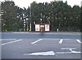
Image Map
Images are licensed for reuse under creativecommons.org/licenses/by-sa/2.0
Notes
- Clicking on the map will re-center to the selected point.
- The higher the marker number, the further away the image location is from the centre of the postcode.
Image Listing (10 Images Found)
Images are licensed for reuse under creativecommons.org/licenses/by-sa/2.0
Image
Details
Distance
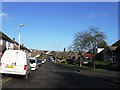
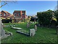
3
Bants Lane
1950s bungalows and 1960s chalet bungalows from a service road in Duston.
Image: © Burgess Von Thunen
Taken: 18 Aug 2014
0.19 miles
4
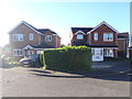
Hawkstone Close
1990s houses in Duston.
Image: © Burgess Von Thunen
Taken: 12 Nov 2015
0.19 miles
5
Timken Way South
2000s houses in Duston.
Image: © Burgess Von Thunen
Taken: 1 Jul 2014
0.20 miles
7
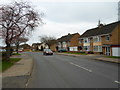
Cotswold Avenue
1960s semis in Duston.
Image: © Burgess Von Thunen
Taken: 10 Mar 2014
0.23 miles

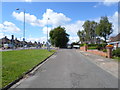
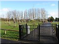
9
New housing nestling up to St Luke's churchyard
Image: © Philip Jeffrey
Taken: 9 Jan 2022
0.24 miles
10
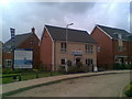
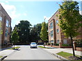
Trinity Green
Bellway Homes show home on the site of the former British Timken factory.
Image: © Burgess Von Thunen
Taken: 8 Sep 2010
0.24 miles