IMAGES TAKEN NEAR TO
Tollgate Way, NORTHAMPTON, NN5 5TW
Introduction
This page details the photographs taken nearby to Tollgate Way, NN5 5TW by members of the Geograph project.
The Geograph project started in 2005 with the aim of publishing, organising and preserving representative images for every square kilometre of Great Britain, Ireland and the Isle of Man.

There are currently over 7.5m images from over14,400 individuals and you can help contribute to the project by visiting https://www.geograph.org.uk
Image Map
Images are licensed for reuse under creativecommons.org/licenses/by-sa/2.0
Notes
- Clicking on the map will re-center to the selected point.
- The higher the marker number, the further away the image location is from the centre of the postcode.
Image Listing (26 Images Found)
Images are licensed for reuse under creativecommons.org/licenses/by-sa/2.0
Image
Details
Distance
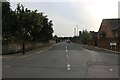
1
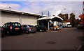
B + S Discount store in Northampton
Formerly Golbey's Garden Centre
Image: © Steve Daniels
Taken: 30 Sep 2009
0.05 miles
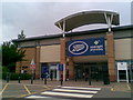
4
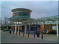
Sainsbury's
Sixfields. Looks like a spaceship to me.
Image: © Burgess Von Thunen
Taken: 6 Apr 2010
0.09 miles
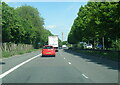
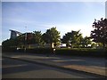
6
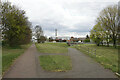
Paths by the A4500
A green buffer between the arterial road and Sixfields Retail Park.
Image: © Bill Boaden
Taken: 16 Apr 2021
0.14 miles
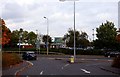
8
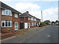
The Scarplands
1950s semis in Duston.
Image: © Burgess Von Thunen
Taken: 2 Jul 2014
0.17 miles
10
Boots
Sixfields. Now you can be poorly at midnight.
Image: © Burgess Von Thunen
Taken: 13 Jun 2010
0.17 miles