IMAGES TAKEN NEAR TO
St. James Road, NORTHAMPTON, NN5 5HS
Introduction
This page details the photographs taken nearby to St. James Road, NN5 5HS by members of the Geograph project.
The Geograph project started in 2005 with the aim of publishing, organising and preserving representative images for every square kilometre of Great Britain, Ireland and the Isle of Man.

There are currently over 7.5m images from over14,400 individuals and you can help contribute to the project by visiting https://www.geograph.org.uk
Image Map (Loading...)


Getting Data...Please wait
Leaflet Map data © OpenStreetMap
Images are licensed for reuse under creativecommons.org/licenses/by-sa/2.0
Notes
- Clicking on the map will re-center to the selected point.
- The higher the marker number, the further away the image location is from the centre of the postcode.
Image Listing (88 Images Found)
Images are licensed for reuse under creativecommons.org/licenses/by-sa/2.0
Image
Details
Distance
2
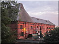
Old Maltings, St. James Road
Recycled with heart, pride and passion.
Image: © Chris
Taken: 2 Jul 2014
0.01 miles
4
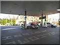
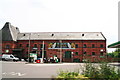
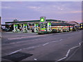
BP petrol station on St James Road, Northampton
Image: © David Howard
Taken: 21 May 2017
0.03 miles
6
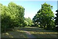
Path in Foot Meadow
Looking across part of this park near West Bridge.
Image: © DS Pugh
Taken: 27 May 2022
0.03 miles
8
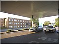
BP petrol station on St James Road, Northampton
Image: © David Howard
Taken: 21 May 2017
0.03 miles
9
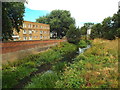
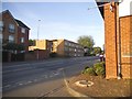
River Nene in Northampton
This channel forms part of the Brampton arm of the River Nene, close to the centre of Northampton.
Image: © Malc McDonald
Taken: 28 Jul 2018
0.04 miles
10
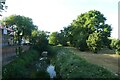
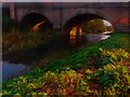
River from West Bridge
Looking north from St. James' Road.
Image: © DS Pugh
Taken: 27 May 2022
0.05 miles