IMAGES TAKEN NEAR TO
Duston Road, NORTHAMPTON, NN5 5AR
Introduction
This page details the photographs taken nearby to Duston Road, NN5 5AR by members of the Geograph project.
The Geograph project started in 2005 with the aim of publishing, organising and preserving representative images for every square kilometre of Great Britain, Ireland and the Isle of Man.

There are currently over 7.5m images from over14,400 individuals and you can help contribute to the project by visiting https://www.geograph.org.uk
Image Map
Images are licensed for reuse under creativecommons.org/licenses/by-sa/2.0
Notes
- Clicking on the map will re-center to the selected point.
- The higher the marker number, the further away the image location is from the centre of the postcode.
Image Listing (14 Images Found)
Images are licensed for reuse under creativecommons.org/licenses/by-sa/2.0
Image
Details
Distance
1
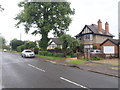
Duston Road
1920s houses in Duston.
Image: © Burgess Von Thunen
Taken: 10 Jun 2016
0.00 miles
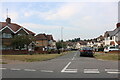
2

Duston Road
1950s semis in St James.
Image: © Burgess Von Thunen
Taken: 10 Nov 2014
0.06 miles
6
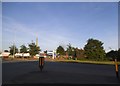
Retail park on Weedon Road, Northampton
Image: © David Howard
Taken: 21 May 2017
0.18 miles
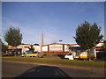
7
Weedon Road Industrial Estate
Matalan clothing and homewares.
Image: © Burgess Von Thunen
Taken: 1 Aug 2011
0.18 miles
8
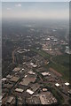
Across Westgate Industrial Estate and along the River Nene into Northampton: aerial 2017
Image: © Chris
Taken: 14 Jun 2017
0.18 miles
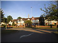
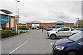
9

Bowling alley on Weedon Road, Northampton
Image: © David Howard
Taken: 21 May 2017
0.24 miles
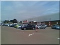
10
Sixfields Retail Park
A retail park west of the town centre.
Image: © Bill Boaden
Taken: 16 Apr 2021
0.24 miles