IMAGES TAKEN NEAR TO
Thompson Close, NORTHAMPTON, NN5 4UE
Introduction
This page details the photographs taken nearby to Thompson Close, NN5 4UE by members of the Geograph project.
The Geograph project started in 2005 with the aim of publishing, organising and preserving representative images for every square kilometre of Great Britain, Ireland and the Isle of Man.

There are currently over 7.5m images from over14,400 individuals and you can help contribute to the project by visiting https://www.geograph.org.uk
Image Map
Images are licensed for reuse under creativecommons.org/licenses/by-sa/2.0
Notes
- Clicking on the map will re-center to the selected point.
- The higher the marker number, the further away the image location is from the centre of the postcode.
Image Listing (26 Images Found)
Images are licensed for reuse under creativecommons.org/licenses/by-sa/2.0
Image
Details
Distance
1
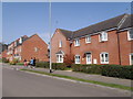
Kent Road
2000s houses in Duston.
Image: © Burgess Von Thunen
Taken: 10 Apr 2015
0.03 miles
2
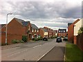
Milburn Drive
2000s houses in St Crispins.
Image: © Burgess Von Thunen
Taken: 24 Jun 2013
0.05 miles
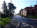
3
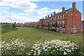
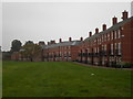
Terrace of town houses lining the playing fields
Image: © Philip Jeffrey
Taken: 13 Jun 2020
0.08 miles
5
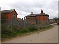
Northampton - Saint Crispins
Derelict buildings of the Hospital Farm.
Image: © Ian Rob
Taken: 31 Oct 2006
0.13 miles
7

St Crispins
2010s flats off St Crispins Drive.
Image: © Burgess Von Thunen
Taken: 2 Feb 2016
0.15 miles
8
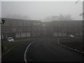
St Crispins
New blocks of flats on a very foggy morning in St Crispins.
Image: © Burgess Von Thunen
Taken: 14 Mar 2014
0.15 miles
9
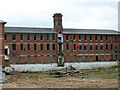
St.Crispin's Hospital
Former wards awaiting re-development
Image: © Richard Croft
Taken: 7 Sep 2011
0.16 miles
10
Frank Large Walk
2000s houses in Duston.
Image: © Burgess Von Thunen
Taken: 19 Sep 2014
0.16 miles