IMAGES TAKEN NEAR TO
West Street, NN5 4HG
Introduction
This page details the photographs taken nearby to West Street, NN5 4HG by members of the Geograph project.
The Geograph project started in 2005 with the aim of publishing, organising and preserving representative images for every square kilometre of Great Britain, Ireland and the Isle of Man.

There are currently over 7.5m images from over14,400 individuals and you can help contribute to the project by visiting https://www.geograph.org.uk
Image Map
Images are licensed for reuse under creativecommons.org/licenses/by-sa/2.0
Notes
- Clicking on the map will re-center to the selected point.
- The higher the marker number, the further away the image location is from the centre of the postcode.
Image Listing (3 Images Found)
Images are licensed for reuse under creativecommons.org/licenses/by-sa/2.0
Image
Details
Distance
1
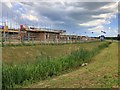
Reeds and new building on Upton Valley Way North
Image: © Philip Jeffrey
Taken: 13 Jun 2020
0.07 miles
2
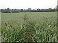
Footpath through Wheat
This section of the Nene Way is inadequately restored as the path is more narrow than specified by regulations.
Image: © Kokai
Taken: 28 Jun 2006
0.21 miles
3
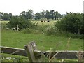
Cattle Grazing
View south from the Nene Way across farmland.
Image: © Kokai
Taken: 28 Jun 2006
0.22 miles