IMAGES TAKEN NEAR TO
Kiltie Street, NORTHAMPTON, NN5 4FR
Introduction
This page details the photographs taken nearby to Kiltie Street, NN5 4FR by members of the Geograph project.
The Geograph project started in 2005 with the aim of publishing, organising and preserving representative images for every square kilometre of Great Britain, Ireland and the Isle of Man.

There are currently over 7.5m images from over14,400 individuals and you can help contribute to the project by visiting https://www.geograph.org.uk
Image Map (Loading...)


Getting Data...Please wait
Leaflet Map data © OpenStreetMap
Images are licensed for reuse under creativecommons.org/licenses/by-sa/2.0
Notes
- Clicking on the map will re-center to the selected point.
- The higher the marker number, the further away the image location is from the centre of the postcode.
Image Listing (42 Images Found)
Images are licensed for reuse under creativecommons.org/licenses/by-sa/2.0
Image
Details
Distance
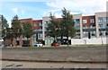
1
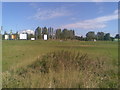
Upton
Land yet to be developed at Upton. Note the advertising hoardings fronting onto Weedon Road.
Image: © Burgess Von Thunen
Taken: 9 Sep 2010
0.03 miles
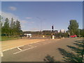
2
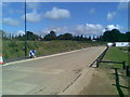
Road to nowhere
A truncated roundabout exit at Upton. Note the Express Lifts Tower in the background.
Image: © Burgess Von Thunen
Taken: 9 Sep 2010
0.04 miles
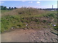
5
Foxfields care home on Weedon Road, Northampton
As you can see it isn't quite finished yet.
Image: © David Howard
Taken: 2 Aug 2020
0.06 miles
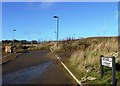
6
High Street
Exit from new development at Upton onto Weedon Road.
Image: © Burgess Von Thunen
Taken: 9 Sep 2010
0.06 miles
7
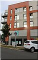
The Co-op on High Street, Upton
This was built in 2016 along with the rest of Upton.
Image: © David Howard
Taken: 1 Sep 2024
0.06 miles
8
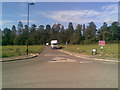
Upton
This road leads to Quinton House school.
Image: © Burgess Von Thunen
Taken: 9 Sep 2010
0.08 miles
9
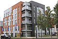
New apartment block
At the junction of High Street and Weedon Road.
Image: © Andrew Abbott
Taken: 4 Jul 2020
0.08 miles
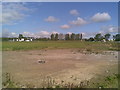
10
Knot Tiers Drive
The current boundary of Barratt Homes' NU@D2 development.
Image: © Burgess Von Thunen
Taken: 9 Sep 2010
0.09 miles