IMAGES TAKEN NEAR TO
Barring Street, NORTHAMPTON, NN5 4DD
Introduction
This page details the photographs taken nearby to Barring Street, NN5 4DD by members of the Geograph project.
The Geograph project started in 2005 with the aim of publishing, organising and preserving representative images for every square kilometre of Great Britain, Ireland and the Isle of Man.

There are currently over 7.5m images from over14,400 individuals and you can help contribute to the project by visiting https://www.geograph.org.uk
Image Map
Images are licensed for reuse under creativecommons.org/licenses/by-sa/2.0
Notes
- Clicking on the map will re-center to the selected point.
- The higher the marker number, the further away the image location is from the centre of the postcode.
Image Listing (49 Images Found)
Images are licensed for reuse under creativecommons.org/licenses/by-sa/2.0
Image
Details
Distance
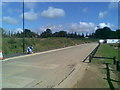
1
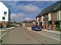
Samwell Lane
Brand new homes. One is already up for resale with Connells.
Image: © Burgess Von Thunen
Taken: 9 Sep 2010
0.05 miles
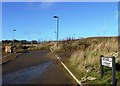
2
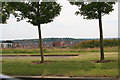
New housing estate south of Weedon Road near Upton
Image: © Chris
Taken: 2 Jul 2014
0.06 miles
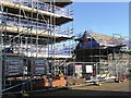
3
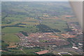
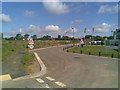
Weedon Road out of Northampton and Upton development: aerial 2014
Image: © Chris
Taken: 2 Jul 2014
0.07 miles
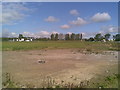
5
Knot Tiers Drive
The current boundary of Barratt Homes' NU@D2 development.
Image: © Burgess Von Thunen
Taken: 9 Sep 2010
0.10 miles
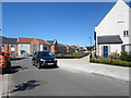
8
Brunel Drive
1990s houses in Upton.
Image: © Burgess Von Thunen
Taken: 6 Feb 2015
0.12 miles
9
Knot Tiers Drive
Barratt Homes advertising on the right.
Image: © Burgess Von Thunen
Taken: 9 Sep 2010
0.13 miles
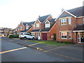
10
Telford Street
2000s houses in Upton.
Image: © Burgess Von Thunen
Taken: 10 Jul 2014
0.14 miles