IMAGES TAKEN NEAR TO
Hawker Way, NORTHAMPTON, NN4 9EW
Introduction
This page details the photographs taken nearby to Hawker Way, NN4 9EW by members of the Geograph project.
The Geograph project started in 2005 with the aim of publishing, organising and preserving representative images for every square kilometre of Great Britain, Ireland and the Isle of Man.

There are currently over 7.5m images from over14,400 individuals and you can help contribute to the project by visiting https://www.geograph.org.uk
Image Map
Images are licensed for reuse under creativecommons.org/licenses/by-sa/2.0
Notes
- Clicking on the map will re-center to the selected point.
- The higher the marker number, the further away the image location is from the centre of the postcode.
Image Listing (13 Images Found)
Images are licensed for reuse under creativecommons.org/licenses/by-sa/2.0
Image
Details
Distance
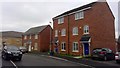
1
Damselfly Road
New homes in Butterfly Gardens.
Image: © Burgess Von Thunen
Taken: 7 Aug 2015
0.04 miles
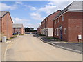
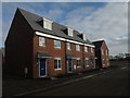
2
Damselfly Road
2010s houses in Pineham.
Image: © Burgess Von Thunen
Taken: 13 Apr 2018
0.05 miles
3
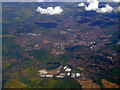
Northampton from the air
Viewed from a Stansted bound flight from Prestwick. The M1 motorway runs across the bottom of the photo.
Image: © Thomas Nugent
Taken: 9 May 2011
0.09 miles
5
Mayfly Road
New homes in Dragonfly Meadow.
Image: © Burgess Von Thunen
Taken: 6 Feb 2015
0.15 miles
7
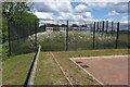
Daisies corralled in the school grounds
Image: © Philip Jeffrey
Taken: 13 Jun 2020
0.17 miles
8
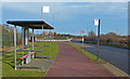
Bus shelter along Upton Valley Way East
Image: © Mat Fascione
Taken: 8 Dec 2013
0.20 miles
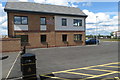
9
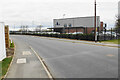
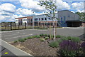
Pineham Barns Primary School
A new school which is part of large industrial and residential development in the area.
Image: © Bill Boaden
Taken: 16 Apr 2021
0.21 miles