IMAGES TAKEN NEAR TO
Narrowboat Lane, NORTHAMPTON, NN4 9DD
Introduction
This page details the photographs taken nearby to Narrowboat Lane, NN4 9DD by members of the Geograph project.
The Geograph project started in 2005 with the aim of publishing, organising and preserving representative images for every square kilometre of Great Britain, Ireland and the Isle of Man.

There are currently over 7.5m images from over14,400 individuals and you can help contribute to the project by visiting https://www.geograph.org.uk
Image Map
Images are licensed for reuse under creativecommons.org/licenses/by-sa/2.0
Notes
- Clicking on the map will re-center to the selected point.
- The higher the marker number, the further away the image location is from the centre of the postcode.
Image Listing (46 Images Found)
Images are licensed for reuse under creativecommons.org/licenses/by-sa/2.0
Image
Details
Distance
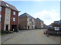
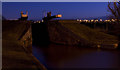
3

Narrowboat Lane
2010s dwellings in Pineham Lock.
Image: © Burgess Von Thunen
Taken: 17 Nov 2015
0.05 miles
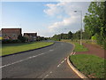
5
Lockgate Road
2010s houses under construction at Pineham Lock.
Image: © Burgess Von Thunen
Taken: 1 Jul 2014
0.08 miles
6
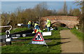
Volunteers at work on Wootton Lock No 14
Next to Banbury Lane Bridge No 9 on the Northampton Arm of the Grand Union Canal.
Image: © Mat Fascione
Taken: 8 Dec 2013
0.10 miles
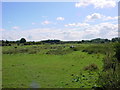
9
Lock near Banbury Lane
Looking towards a lock on the Northampton Branch of the Grand Union Canal.
Image: © DS Pugh
Taken: 27 May 2022
0.12 miles
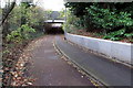
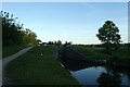
10
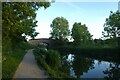
Banbury Lane Bridge
Looking along the Northampton Branch of the Grand Union Canal.
Image: © DS Pugh
Taken: 27 May 2022
0.12 miles