IMAGES TAKEN NEAR TO
Coverack Close, NORTHAMPTON, NN4 8PQ
Introduction
This page details the photographs taken nearby to Coverack Close, NN4 8PQ by members of the Geograph project.
The Geograph project started in 2005 with the aim of publishing, organising and preserving representative images for every square kilometre of Great Britain, Ireland and the Isle of Man.

There are currently over 7.5m images from over14,400 individuals and you can help contribute to the project by visiting https://www.geograph.org.uk
Image Map
Images are licensed for reuse under creativecommons.org/licenses/by-sa/2.0
Notes
- Clicking on the map will re-center to the selected point.
- The higher the marker number, the further away the image location is from the centre of the postcode.
Image Listing (14 Images Found)
Images are licensed for reuse under creativecommons.org/licenses/by-sa/2.0
Image
Details
Distance
1
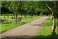
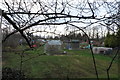
Towcester Road Cemetery, Northampton
There are separate sections devoted to Jewish, Moslem and Chinese graves within this large cemetery run by Northampton Borough Council.
Image: © Stephen McKay
Taken: 12 Jun 2007
0.11 miles
3
Roundabout on Towcester Road, Far Cotton
Image: © David Howard
Taken: 8 Aug 2012
0.14 miles
4
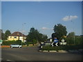
Roundabout on Towcester Road, Far Cotton
Image: © David Howard
Taken: 8 Aug 2012
0.15 miles
5
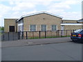
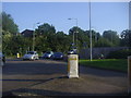
Telephone Exchange, Far Cotton (2)
This photo shows the Western half of the TE in Gloucester Avenue. It has (01604) 70xxxx, 76xxxx numbers, the (01604) referring to the Northampton group of TEs, and its postcode is NN4 8QF.
Image: © David Hillas
Taken: 17 May 2014
0.15 miles
6
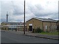
Telephone Exchange, Far Cotton (1)
Situated in Gloucester Avenue, this modern TE rather resembles a school and used to take the name "Hardingstone" a village nearby. It serves the Southern part of Northampton plus Collingtree, Grange Park, Great Houghton, Hardingstone and Wootton nearby. The mobile phone mast can be seen behind the TE to the left of the photo whilst a telegraph pole is by the road in front of the TE.
Image: © David Hillas
Taken: 20 Jun 2009
0.16 miles
7
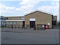
Telephone Exchange, Far Cotton (3)
This photo taken in Gloucester Avenue shows the Eastern part of this modern TE with a BT warning notice and a red rubbish container to the right of it. The building has been kept in good condition with the doors looking as if they have recently been repainted.
Image: © David Hillas
Taken: 17 May 2014
0.16 miles
8
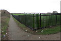
Towcester Road
A service road off Towcester in Delepre.
Image: © Burgess Von Thunen
Taken: 16 May 2016
0.18 miles
10
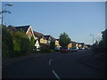
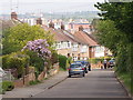
Lancaster Way, Far Cotton
Typical early 21st century anonymous new houses. The gables have been revived from the 1930s.
Image: © David Howard
Taken: 8 Aug 2012
0.20 miles