IMAGES TAKEN NEAR TO
Delapre Street, NORTHAMPTON, NN4 8HA
Introduction
This page details the photographs taken nearby to Delapre Street, NN4 8HA by members of the Geograph project.
The Geograph project started in 2005 with the aim of publishing, organising and preserving representative images for every square kilometre of Great Britain, Ireland and the Isle of Man.

There are currently over 7.5m images from over14,400 individuals and you can help contribute to the project by visiting https://www.geograph.org.uk
Image Map
Images are licensed for reuse under creativecommons.org/licenses/by-sa/2.0
Notes
- Clicking on the map will re-center to the selected point.
- The higher the marker number, the further away the image location is from the centre of the postcode.
Image Listing (23 Images Found)
Images are licensed for reuse under creativecommons.org/licenses/by-sa/2.0
Image
Details
Distance
1
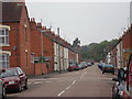
Thirlestane Road
Victorian terraces in Far Cotton.
Image: © Burgess Von Thunen
Taken: 11 Sep 2014
0.01 miles
2
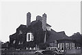
An old house at Far Cotton
This picture is of an old Victorian house taken in 1939. The house was called "Fieldside" and was situated on the south corner of the junction of Rothersthorpe Road with Towcester Road. In 1939 there were fields the other side of both Rothersthorpe Road and Towcester Road. There was a tram terminus opposite the house with a shelter in the centre of Towcester Road. The site is now occupied by a supermarket.
Image: © Anthony Harrison
Taken: Unknown
0.07 miles
3
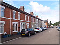
Thirlestaine Road
Victorian terraces in Far Cotton.
Image: © Burgess Von Thunen
Taken: 4 Sep 2015
0.07 miles
4
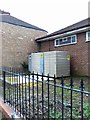
Electricity sub station, Towcester Road
Image: © Alex McGregor
Taken: 5 Oct 2012
0.10 miles
5
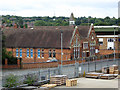
Former school, Main Road
Now community rooms.
Image: © Robin Webster
Taken: 4 Sep 2016
0.15 miles
6
Main Road from St Leonards Road, Cotton End
Image: © David Howard
Taken: 8 Aug 2012
0.16 miles
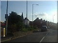
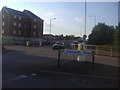
7
Towcester Road, Far Cotton
At the lights for Queen Eleanor Road
Image: © David Howard
Taken: 8 Aug 2012
0.16 miles
8
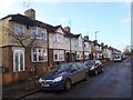
Penrhyn Road
1930s houses in Far Cotton.
Image: © Burgess Von Thunen
Taken: 23 Dec 2015
0.16 miles
9
Towcester Road at the junction of St Leonards Road
Image: © David Howard
Taken: 8 Aug 2012
0.17 miles
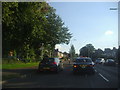
10
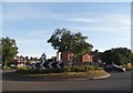
Roundabout on Towcester Road, Northampton
Image: © David Howard
Taken: 21 May 2017
0.17 miles