IMAGES TAKEN NEAR TO
Penrhyn Road, NORTHAMPTON, NN4 8ED
Introduction
This page details the photographs taken nearby to Penrhyn Road, NN4 8ED by members of the Geograph project.
The Geograph project started in 2005 with the aim of publishing, organising and preserving representative images for every square kilometre of Great Britain, Ireland and the Isle of Man.

There are currently over 7.5m images from over14,400 individuals and you can help contribute to the project by visiting https://www.geograph.org.uk
Image Map
Images are licensed for reuse under creativecommons.org/licenses/by-sa/2.0
Notes
- Clicking on the map will re-center to the selected point.
- The higher the marker number, the further away the image location is from the centre of the postcode.
Image Listing (43 Images Found)
Images are licensed for reuse under creativecommons.org/licenses/by-sa/2.0
Image
Details
Distance
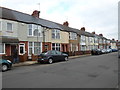
1
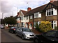
Penrhyn Road
1930s bay-fronted terraces in Far Cotton.
Image: © Burgess Von Thunen
Taken: 12 Aug 2013
0.02 miles
2
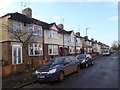
Penrhyn Road
1930s houses in Far Cotton.
Image: © Burgess Von Thunen
Taken: 23 Dec 2015
0.05 miles
3
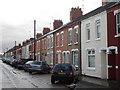
Euston Road
Victorian terraces in Far Cotton.
Image: © Burgess Von Thunen
Taken: 12 Nov 2014
0.07 miles
4
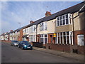
Delepre Crescent Road
1920s houses in Far Cotton.
Image: © Burgess Von Thunen
Taken: 10 Apr 2015
0.08 miles
5
Delepre Crescent Road
1920s terraces in Far Cotton.
Image: © Burgess Von Thunen
Taken: 18 Feb 2014
0.09 miles
6
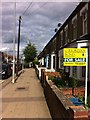
St Leonards Road
House for sale with O'Riordan Bond in Far Cotton.
Image: © Burgess Von Thunen
Taken: 22 Jun 2013
0.10 miles
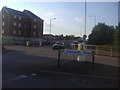
7
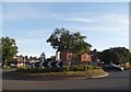
Roundabout on Towcester Road, Northampton
Image: © David Howard
Taken: 21 May 2017
0.10 miles
8
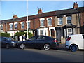
Terrace on St Leonard's Road, Northampton
Image: © David Howard
Taken: 21 May 2017
0.11 miles
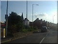
9
Towcester Road at the junction of St Leonards Road
Image: © David Howard
Taken: 8 Aug 2012
0.11 miles
10
Main Road from St Leonards Road, Cotton End
Image: © David Howard
Taken: 8 Aug 2012
0.11 miles