IMAGES TAKEN NEAR TO
St. Leonards Road, NORTHAMPTON, NN4 8DN
Introduction
This page details the photographs taken nearby to St. Leonards Road, NN4 8DN by members of the Geograph project.
The Geograph project started in 2005 with the aim of publishing, organising and preserving representative images for every square kilometre of Great Britain, Ireland and the Isle of Man.

There are currently over 7.5m images from over14,400 individuals and you can help contribute to the project by visiting https://www.geograph.org.uk
Image Map
Images are licensed for reuse under creativecommons.org/licenses/by-sa/2.0
Notes
- Clicking on the map will re-center to the selected point.
- The higher the marker number, the further away the image location is from the centre of the postcode.
Image Listing (107 Images Found)
Images are licensed for reuse under creativecommons.org/licenses/by-sa/2.0
Image
Details
Distance
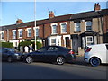
1
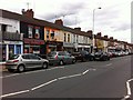
St Leonards Road
Shops in Far Cotton, mostly fast food restaurants, including a dry cleaners, Akbor Tandoori, Far Cotton Tandoori, a nail bar, Ying Lung, Empress and Jennys.
Image: © Burgess Von Thunen
Taken: 22 Jun 2013
0.02 miles
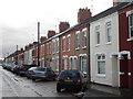
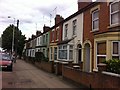
2
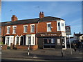
Terrace on St Leonard's Road, Northampton
Presumably no one flies into the hairdresser now.
Image: © David Howard
Taken: 21 May 2017
0.04 miles
3
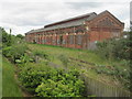
Old railway shed, Northampton (Bridge Street) railway station
The shed and some rusty track are all that survive of this former railway station, which was located just beyond the far end of the shed.
Image: © Nigel Thompson
Taken: 24 May 2016
0.05 miles
4
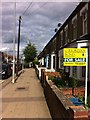
St Leonards Road
House for sale with O'Riordan Bond in Far Cotton.
Image: © Burgess Von Thunen
Taken: 22 Jun 2013
0.06 miles
5
Terrace on St Leonard's Road, Northampton
Image: © David Howard
Taken: 21 May 2017
0.06 miles
6
Euston Road
Victorian terraces in Far Cotton.
Image: © Burgess Von Thunen
Taken: 12 Nov 2014
0.08 miles
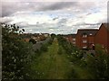
7
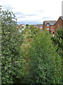
Course of old railway, Northampton
The LNWR Northampton and Peterborough line, looking towards the site of Bridge Street station. There are still rails over this part, as far as a Network Rail maintenance depot there, but they seem to have given up using the railway to reach it.
Image: © Robin Webster
Taken: 4 Sep 2016
0.09 miles
8
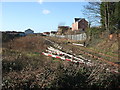
Northampton Bridge Street railway station (site)
Opened in 1845 on the London & North Western Railway's line from Blisworth to Peterborough, this station closed in 1964 to passengers and completely in 1972.
View west from the former Cotton End level crossing towards Blisworth. No trace appeared to remain except for the old shed in the distance, and the periphery of the site has been lost to housing development. By 2016, the site was unaltered except for vegetation encroachment, blocking much of the view.
Image: © Nigel Thompson
Taken: 20 Jan 2007
0.11 miles
9
St Leonards Road
Bay-fronted Victorian terraces in Far Cotton.
Image: © Burgess Von Thunen
Taken: 22 Jun 2013
0.11 miles
10
Midland Railway
Old track bed passing through modern housing in Cotton End.
Image: © Burgess Von Thunen
Taken: 22 Jun 2013
0.11 miles