IMAGES TAKEN NEAR TO
Southfield Avenue, NORTHAMPTON, NN4 8BP
Introduction
This page details the photographs taken nearby to Southfield Avenue, NN4 8BP by members of the Geograph project.
The Geograph project started in 2005 with the aim of publishing, organising and preserving representative images for every square kilometre of Great Britain, Ireland and the Isle of Man.

There are currently over 7.5m images from over14,400 individuals and you can help contribute to the project by visiting https://www.geograph.org.uk
Image Map
Images are licensed for reuse under creativecommons.org/licenses/by-sa/2.0
Notes
- Clicking on the map will re-center to the selected point.
- The higher the marker number, the further away the image location is from the centre of the postcode.
Image Listing (52 Images Found)
Images are licensed for reuse under creativecommons.org/licenses/by-sa/2.0
Image
Details
Distance
1
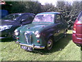
Austin A35
At the Northampton Society of Model Engineers.
Image: © Burgess Von Thunen
Taken: 5 Sep 2010
0.05 miles
2
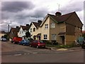
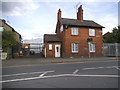
Claughton Road
1920s railway workers' houses in Far Cotton.
Image: © Burgess Von Thunen
Taken: 22 Jun 2013
0.06 miles
3
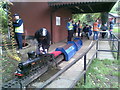
Northampton Society of Model Engineers
This model live steam, passenger-carrying model railway operates on the first Sunday of every month during the summer.
Image: © Burgess Von Thunen
Taken: 5 Sep 2010
0.06 miles
5
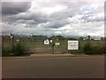
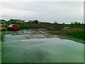
Ransome Road
Phase 1 remediation works being undertaken by Hydrock Group Ltd on the site of former railway sidings earmarked for development, possibly as a new university campus, as part of the Northampton Waterside Enterprise Zone.
Image: © Burgess Von Thunen
Taken: 22 Jun 2013
0.09 miles
6
Electricity substation on London Road, Northampton
Image: © David Howard
Taken: 20 Sep 2020
0.09 miles
7
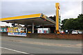
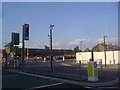
Jet petrol station on London Road, Far Cotton
Image: © David Howard
Taken: 2 Aug 2022
0.10 miles
8
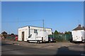
House on Cotton End, Northampton
A tyre fitters is behind it, the buildings are all part of one group.
Image: © David Howard
Taken: 21 May 2017
0.10 miles
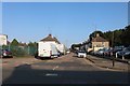
10
London Road overlooking Ransome Road
Asda was Netto until not that long ago.
Image: © David Howard
Taken: 8 Aug 2012
0.12 miles