IMAGES TAKEN NEAR TO
Delapre Park, NORTHAMPTON, NN4 7BS
Introduction
This page details the photographs taken nearby to Delapre Park, NN4 7BS by members of the Geograph project.
The Geograph project started in 2005 with the aim of publishing, organising and preserving representative images for every square kilometre of Great Britain, Ireland and the Isle of Man.

There are currently over 7.5m images from over14,400 individuals and you can help contribute to the project by visiting https://www.geograph.org.uk
Image Map
Images are licensed for reuse under creativecommons.org/licenses/by-sa/2.0
Notes
- Clicking on the map will re-center to the selected point.
- The higher the marker number, the further away the image location is from the centre of the postcode.
Image Listing (5 Images Found)
Images are licensed for reuse under creativecommons.org/licenses/by-sa/2.0
Image
Details
Distance
2
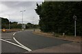
Pavilion Drive at the junction of Nene Valley Way
This is an entrance and exit to Brackmills Industrial Estate, which I'd never heard of till I found myself there instead of Northampton due to the efforts by the council to divert all foreigners like me out of the centre and into strange corners. The estate is the size as an entire suburb.
Image: © David Howard
Taken: 2 Aug 2022
0.15 miles
3
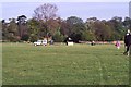
Trees by the water skiing lake
Preparing for a balloon flight
Image: © Philip Jeffrey
Taken: Unknown
0.17 miles
4
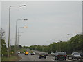
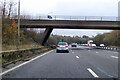
A45 Northampton East
The A45 Nene Valley Way in Northampton coming towards the junction of Brackmills Industrial Estate.
Image: © Jareth W
Taken: 5 May 2014
0.18 miles
5
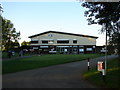
Delapre Golf Centre Clubhouse
Beautiful setting for this very busy facility.
Image: © Ian Paterson
Taken: 24 May 2007
0.20 miles