IMAGES TAKEN NEAR TO
Battalion Drive, NORTHAMPTON, NN4 6RU
Introduction
This page details the photographs taken nearby to Battalion Drive, NN4 6RU by members of the Geograph project.
The Geograph project started in 2005 with the aim of publishing, organising and preserving representative images for every square kilometre of Great Britain, Ireland and the Isle of Man.

There are currently over 7.5m images from over14,400 individuals and you can help contribute to the project by visiting https://www.geograph.org.uk
Image Map
Images are licensed for reuse under creativecommons.org/licenses/by-sa/2.0
Notes
- Clicking on the map will re-center to the selected point.
- The higher the marker number, the further away the image location is from the centre of the postcode.
Image Listing (9 Images Found)
Images are licensed for reuse under creativecommons.org/licenses/by-sa/2.0
Image
Details
Distance
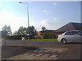
2
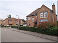
Battalion Drive
1990s houses on Simpson Manor.
Image: © Burgess Von Thunen
Taken: 15 Jul 2015
0.11 miles
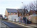
3
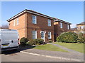
Edwardian Close
1990s houses in Wootton.
Image: © Burgess Von Thunen
Taken: 17 Mar 2016
0.11 miles
6
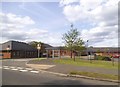
Newport Pagnell Road, Hardingstone
The buildings are the back of a school
Image: © David Howard
Taken: 8 Aug 2012
0.17 miles
8
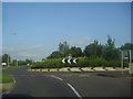
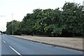
Roundabout on Newport Pagnell Road, Wootton
Image: © David Howard
Taken: 8 Aug 2012
0.19 miles