IMAGES TAKEN NEAR TO
Chariot Road, NORTHAMPTON, NN4 6JP
Introduction
This page details the photographs taken nearby to Chariot Road, NN4 6JP by members of the Geograph project.
The Geograph project started in 2005 with the aim of publishing, organising and preserving representative images for every square kilometre of Great Britain, Ireland and the Isle of Man.

There are currently over 7.5m images from over14,400 individuals and you can help contribute to the project by visiting https://www.geograph.org.uk
Image Map
Images are licensed for reuse under creativecommons.org/licenses/by-sa/2.0
Notes
- Clicking on the map will re-center to the selected point.
- The higher the marker number, the further away the image location is from the centre of the postcode.
Image Listing (16 Images Found)
Images are licensed for reuse under creativecommons.org/licenses/by-sa/2.0
Image
Details
Distance
1
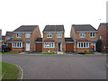
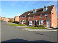
Chariot Road
2000s link detached houses in Wootton Fields.
Image: © Burgess Von Thunen
Taken: 13 Jan 2015
0.04 miles
2
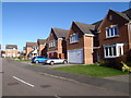
Roman Close
Detached 2000s houses in Wootton Fields.
Image: © Burgess Von Thunen
Taken: 2 Feb 2016
0.07 miles
3
Gladiator Close
2000s houses in Wootton.
Image: © Burgess Von Thunen
Taken: 26 Mar 2014
0.07 miles
5
Romulus Close
2000s houses in Wootton Fields.
Image: © Burgess Von Thunen
Taken: 6 Nov 2014
0.12 miles
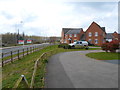
6
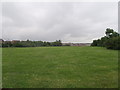
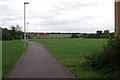
Wootton Fields
Recreation fields in Northampton.
Image: © Burgess Von Thunen
Taken: 13 Jun 2016
0.12 miles
8
Villa Way
2000s houses in Wootton Fields.
Image: © Burgess Von Thunen
Taken: 13 Jun 2016
0.14 miles
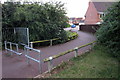
9
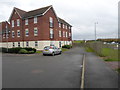
Robinson Way
2000s flats in Wootton Fields.
Image: © Burgess Von Thunen
Taken: 13 Nov 2014
0.15 miles
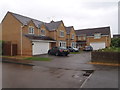
10

Gladiator Close
2000s houses in Wootton Fields.
Image: © Burgess Von Thunen
Taken: 26 Nov 2015
0.16 miles