IMAGES TAKEN NEAR TO
Farmers Close, NORTHAMPTON, NN4 6HS
Introduction
This page details the photographs taken nearby to Farmers Close, NN4 6HS by members of the Geograph project.
The Geograph project started in 2005 with the aim of publishing, organising and preserving representative images for every square kilometre of Great Britain, Ireland and the Isle of Man.

There are currently over 7.5m images from over14,400 individuals and you can help contribute to the project by visiting https://www.geograph.org.uk
Image Map
Images are licensed for reuse under creativecommons.org/licenses/by-sa/2.0
Notes
- Clicking on the map will re-center to the selected point.
- The higher the marker number, the further away the image location is from the centre of the postcode.
Image Listing (12 Images Found)
Images are licensed for reuse under creativecommons.org/licenses/by-sa/2.0
Image
Details
Distance
1
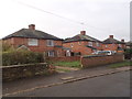
Berry Lane
1930s council houses in Wootton.
Image: © Burgess Von Thunen
Taken: 26 Nov 2015
0.05 miles
2
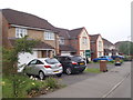
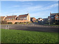
Walkers Way
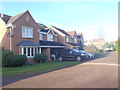
2000s detached houses in Wootton Fields.
Image: © Burgess Von Thunen
Taken: 3 Jun 2016
0.10 miles
3
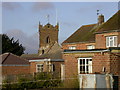
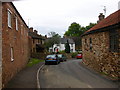
Church at Wootton
Taken from near the recreation ground.
Image: © Kokai
Taken: 29 Jan 2006
0.13 miles
5
Wootton High Street
Wootton Working Men's Club on the corner of Church Hill.
Image: © Ian Rob
Taken: 16 May 2007
0.19 miles
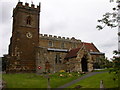
6
Wootton-Church Hill
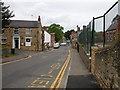
Cottages on Church Hill.
Image: © Ian Rob
Taken: 16 May 2007
0.19 miles
7
Cowbeck Close
2000s houses in Wootton Fields.
Image: © Burgess Von Thunen
Taken: 4 Dec 2015
0.22 miles
8
Sorrel Close
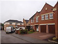
Large 2000s detached houses in Wootton Fields.
Image: © Burgess Von Thunen
Taken: 4 Nov 2016
0.22 miles
9
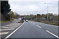
Southbound A45 London Road
By the exit to Wootton.
Image: © Robin Webster
Taken: 5 Dec 2021
0.23 miles
10
Quinton Road
At the junction with Curtlee Hill.
Image: © Burgess Von Thunen
Taken: 4 Dec 2015
0.24 miles