IMAGES TAKEN NEAR TO
Farmclose Road, NORTHAMPTON, NN4 6HJ
Introduction
This page details the photographs taken nearby to Farmclose Road, NN4 6HJ by members of the Geograph project.
The Geograph project started in 2005 with the aim of publishing, organising and preserving representative images for every square kilometre of Great Britain, Ireland and the Isle of Man.

There are currently over 7.5m images from over14,400 individuals and you can help contribute to the project by visiting https://www.geograph.org.uk
Image Map
Images are licensed for reuse under creativecommons.org/licenses/by-sa/2.0
Notes
- Clicking on the map will re-center to the selected point.
- The higher the marker number, the further away the image location is from the centre of the postcode.
Image Listing (15 Images Found)
Images are licensed for reuse under creativecommons.org/licenses/by-sa/2.0
Image
Details
Distance
1
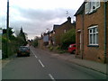
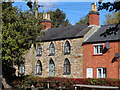
Water Lane
A mix of cottages and modern houses.
Image: © Burgess Von Thunen
Taken: 8 Apr 2011
0.07 miles
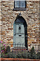
2
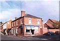
D H Hillyer, Butchers, Wootton, Northamptonshire
The butchers shop has become a chemist in recent years.
Image: © nick macneill
Taken: 25 Nov 1991
0.11 miles
3
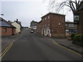
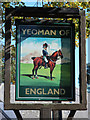
Junction of High Street with Sunnyside
Junction of High Street with Sunnyside by the Yeoman of England pub in Wootton
Image: © Shaun Ferguson
Taken: 17 Feb 2011
0.12 miles
6
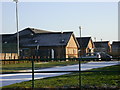
Wootton Community and Sports Centre
A bright and frosty morning.
Image: © Kokai
Taken: 29 Jan 2006
0.13 miles
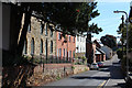
10
Wootton High Street
Wootton Working Men's Club on the corner of Church Hill.
Image: © Ian Rob
Taken: 16 May 2007
0.16 miles