IMAGES TAKEN NEAR TO
Clover Lane, NORTHAMPTON, NN4 6FT
Introduction
This page details the photographs taken nearby to Clover Lane, NN4 6FT by members of the Geograph project.
The Geograph project started in 2005 with the aim of publishing, organising and preserving representative images for every square kilometre of Great Britain, Ireland and the Isle of Man.

There are currently over 7.5m images from over14,400 individuals and you can help contribute to the project by visiting https://www.geograph.org.uk
Image Map
Images are licensed for reuse under creativecommons.org/licenses/by-sa/2.0
Notes
- Clicking on the map will re-center to the selected point.
- The higher the marker number, the further away the image location is from the centre of the postcode.
Image Listing (8 Images Found)
Images are licensed for reuse under creativecommons.org/licenses/by-sa/2.0
Image
Details
Distance
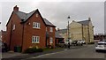
1
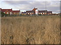
Outer Suburb
A lot of new estates have appeared in this area.
Image: © Kokai
Taken: 29 Jan 2006
0.08 miles
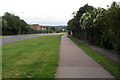
2
Sorrel Crescent
2010s houses on Morris Homes' St Georges Fields development.
Image: © Burgess Von Thunen
Taken: 7 Jan 2019
0.17 miles
4
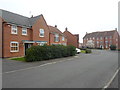
Elm Grove
2000s houses in Wootton.
Image: © Burgess Von Thunen
Taken: 2 Apr 2014
0.21 miles
5
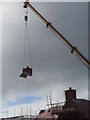
St Georges Fields
"Chimney" being lifted into place on a new house in St Georges Fields.
Image: © Burgess Von Thunen
Taken: 12 Nov 2015
0.22 miles