IMAGES TAKEN NEAR TO
High Street, NORTHAMPTON, NN4 6BZ
Introduction
This page details the photographs taken nearby to High Street, NN4 6BZ by members of the Geograph project.
The Geograph project started in 2005 with the aim of publishing, organising and preserving representative images for every square kilometre of Great Britain, Ireland and the Isle of Man.

There are currently over 7.5m images from over14,400 individuals and you can help contribute to the project by visiting https://www.geograph.org.uk
Image Map
Images are licensed for reuse under creativecommons.org/licenses/by-sa/2.0
Notes
- Clicking on the map will re-center to the selected point.
- The higher the marker number, the further away the image location is from the centre of the postcode.
Image Listing (21 Images Found)
Images are licensed for reuse under creativecommons.org/licenses/by-sa/2.0
Image
Details
Distance
1
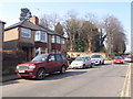
High Street
1930s semis in Hardingstone.
Image: © Burgess Von Thunen
Taken: 10 Apr 2015
0.02 miles
2
Bouverie Road
1950s houses in Hardingstone.
Image: © Burgess Von Thunen
Taken: 6 Aug 2010
0.05 miles
3
High Street
1970s terraces in Hardingstone.
Image: © Burgess Von Thunen
Taken: 6 Aug 2010
0.06 miles
4
Footpath by the Church of Saint Edmund, King and Martyr
Image: © Philip Jeffrey
Taken: 6 Jan 2019
0.08 miles
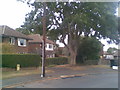
5
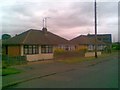
Bouverie Road
1950s bungalows in Hardingstone.
Image: © Burgess Von Thunen
Taken: 6 Aug 2010
0.08 miles
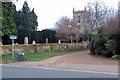
6
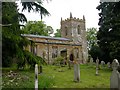
Hardingstone
The Church of Saint Edmund, King and Martyr.
Image: © Ian Rob
Taken: 16 May 2007
0.09 miles
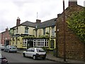
7
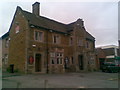
The Crown
A Victorian pub in Hardingstone.
Image: © Burgess Von Thunen
Taken: 6 Aug 2010
0.09 miles
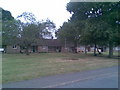
8
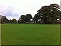
Hardingstone
Recreation ground, backing onto Bouverie Road.
Image: © Burgess Von Thunen
Taken: 12 Oct 2013
0.09 miles
9
Hardingstone
The Sun Public House and Cottages.
Image: © Ian Rob
Taken: 16 May 2007
0.10 miles
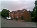
10
Bouverie Road
Sheltered accommodation in Hardingstone.
Image: © Burgess Von Thunen
Taken: 6 Aug 2010
0.10 miles