IMAGES TAKEN NEAR TO
Augusta Avenue, NORTHAMPTON, NN4 0XP
Introduction
This page details the photographs taken nearby to Augusta Avenue, NN4 0XP by members of the Geograph project.
The Geograph project started in 2005 with the aim of publishing, organising and preserving representative images for every square kilometre of Great Britain, Ireland and the Isle of Man.

There are currently over 7.5m images from over14,400 individuals and you can help contribute to the project by visiting https://www.geograph.org.uk
Image Map
Images are licensed for reuse under creativecommons.org/licenses/by-sa/2.0
Notes
- Clicking on the map will re-center to the selected point.
- The higher the marker number, the further away the image location is from the centre of the postcode.
Image Listing (17 Images Found)
Images are licensed for reuse under creativecommons.org/licenses/by-sa/2.0
Image
Details
Distance
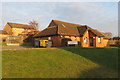
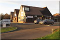
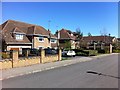
1
Frosty Hollow
Detached houses in Collingtree Park.
Image: © Burgess Von Thunen
Taken: 18 Sep 2014
0.13 miles
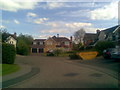
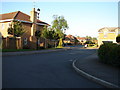
2
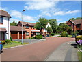
Laneside Hollow
1980s houses in Collingtree Park.
Image: © Burgess Von Thunen
Taken: 4 Jul 2014
0.15 miles
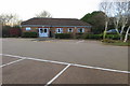
3
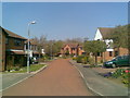
Laneside Hollow
Modern houses just in Collingtree Park with red road surface to reduce speed.
Image: © Burgess Von Thunen
Taken: 23 Apr 2010
0.16 miles
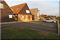
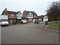
4
Turnberry Lane
Large 1990s detached houses in Collingtree Park.
Image: © Burgess Von Thunen
Taken: 1 May 2013
0.18 miles
5
Turnberry Lane, Northampton
Some fairly large houses in this little estate adjoining the Golf Course.
Image: © Ian Paterson
Taken: 24 May 2007
0.18 miles