IMAGES TAKEN NEAR TO
Wayside Acres, NORTHAMPTON, NN4 0QE
Introduction
This page details the photographs taken nearby to Wayside Acres, NN4 0QE by members of the Geograph project.
The Geograph project started in 2005 with the aim of publishing, organising and preserving representative images for every square kilometre of Great Britain, Ireland and the Isle of Man.

There are currently over 7.5m images from over14,400 individuals and you can help contribute to the project by visiting https://www.geograph.org.uk
Image Map
Images are licensed for reuse under creativecommons.org/licenses/by-sa/2.0
Notes
- Clicking on the map will re-center to the selected point.
- The higher the marker number, the further away the image location is from the centre of the postcode.
Image Listing (20 Images Found)
Images are licensed for reuse under creativecommons.org/licenses/by-sa/2.0
Image
Details
Distance
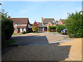
1
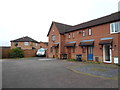
Lindisfarne Way
1990s houses in East Hunsbury.
Image: © Burgess Von Thunen
Taken: 17 Feb 2014
0.06 miles
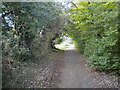
2
Footpath parallel to Mere Way, Far Cotton (2)
Sandwiched between the busy dual carriageway (right) and Abbeyfield School (left).
Image: © Richard Vince
Taken: 9 Oct 2021
0.10 miles
3
Footpath parallel to Mere Way, Far Cotton (3)
Sandwiched between the busy dual carriageway (left) and Abbeyfield School (right).
Image: © Richard Vince
Taken: 9 Oct 2021
0.10 miles
4
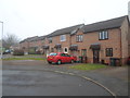
Stagshaw Close
1980s houses in East Hunsbury.
Image: © Burgess Von Thunen
Taken: 10 Feb 2015
0.12 miles
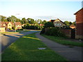
5
Olympia Close
1980s houses in Merefield.
Image: © Burgess Von Thunen
Taken: 23 Sep 2014
0.13 miles
6
Three twelves
1980s houses in Merefield.
Image: © Burgess Von Thunen
Taken: 25 Sep 2015
0.14 miles
7
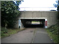
Subway under Mere Way, Merefield
Used by a cycleway (left) and footpath.
Image: © Richard Vince
Taken: 9 Oct 2021
0.14 miles
8
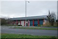
Hardwick Road, Northampton
Penvale Park Medical Centre is the main building in the picture. The Radio Mast can be seen behind the Medical Centre roof.
Image: © Ian Paterson
Taken: 24 May 2007
0.15 miles
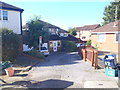
9
Mereway fire station
Mereway fire station, Mere Way, Northampton, Northamptonshire
Image: © Kevin Hale
Taken: 4 Dec 2007
0.16 miles
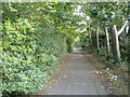
10
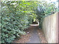
Footpath parallel to Mere Way, Far Cotton (1)
Visually (but sadly not aurally) separated from the busy dual carriageway by somewhat overgrown vegetation (left).
Image: © Richard Vince
Taken: 9 Oct 2021
0.16 miles