IMAGES TAKEN NEAR TO
Chilwell Court, NORTHAMPTON, NN3 9UR
Introduction
This page details the photographs taken nearby to Chilwell Court, NN3 9UR by members of the Geograph project.
The Geograph project started in 2005 with the aim of publishing, organising and preserving representative images for every square kilometre of Great Britain, Ireland and the Isle of Man.

There are currently over 7.5m images from over14,400 individuals and you can help contribute to the project by visiting https://www.geograph.org.uk
Image Map
Images are licensed for reuse under creativecommons.org/licenses/by-sa/2.0
Notes
- Clicking on the map will re-center to the selected point.
- The higher the marker number, the further away the image location is from the centre of the postcode.
Image Listing (8 Images Found)
Images are licensed for reuse under creativecommons.org/licenses/by-sa/2.0
Image
Details
Distance
1
Nuthall Close
1980s houses in Wakes Meadow.
Image: © Burgess Von Thunen
Taken: 17 Nov 2015
0.11 miles
2
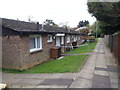
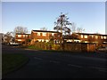
Flaxwell Court
1970s council bungalows in Standens Barn.
Image: © Burgess Von Thunen
Taken: 22 Oct 2015
0.12 miles
3
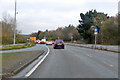
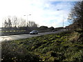
Traffic queuing on A43 Lumbertubs Way
There are traffic lights at the roundabout for the A45 junction.
Image: © Robin Webster
Taken: 5 Dec 2021
0.13 miles
4
Wilford Avenue
1980s semis in Wakes Meadow.
Image: © Burgess Von Thunen
Taken: 3 Feb 2016
0.14 miles
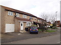
5
Flaxwell Court
1970s council houses in Standens Barn.
Image: © Burgess Von Thunen
Taken: 19 Dec 2013
0.14 miles
6
Nene Valley Way
A45 south of Little Billing.
Image: © Burgess Von Thunen
Taken: 28 Dec 2013
0.18 miles
7
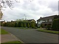
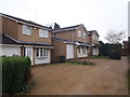
Thorburn Road
Large 1970s houses in Weston Favell.
Image: © Burgess Von Thunen
Taken: 30 Apr 2013
0.23 miles
8
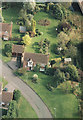
Home for a bit
Church Lane. 17 years ago it was a field. The builders raised the level and built six houses there. At the top of the picture is a stream which flows into Billing Aquadrome. The A45 is in the top right corner. The picture was taken Aug 2000.
Image: © Ian
Taken: Unknown
0.24 miles