IMAGES TAKEN NEAR TO
Fieldmill Road, NORTHAMPTON, NN3 9DG
Introduction
This page details the photographs taken nearby to Fieldmill Road, NN3 9DG by members of the Geograph project.
The Geograph project started in 2005 with the aim of publishing, organising and preserving representative images for every square kilometre of Great Britain, Ireland and the Isle of Man.

There are currently over 7.5m images from over14,400 individuals and you can help contribute to the project by visiting https://www.geograph.org.uk
Image Map (8 Images)


Leaflet Map data © OpenStreetMap
Images are licensed for reuse under creativecommons.org/licenses/by-sa/2.0
Notes
- Clicking on the map will re-center to the selected point.
- The higher the marker number, the further away the image location is from the centre of the postcode.
Image Listing (8 Images Found)
Images are licensed for reuse under creativecommons.org/licenses/by-sa/2.0
Image
Details
Distance
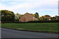
2
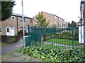
Bellinge
These steel fences have been erected in the pathways between the various courts to stop kids on mopeds rampaging through the estate.
Image: © Burgess Von Thunen
Taken: 21 Oct 2013
0.12 miles
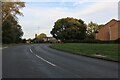
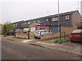
3

Foskitt Court South
1970s council houses in Bellinge.
Image: © Burgess Von Thunen
Taken: 23 Jun 2014
0.14 miles
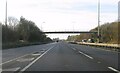
4
Campion Court
1980s council houses in Bellinge.
Image: © Burgess Von Thunen
Taken: 10 May 2016
0.16 miles
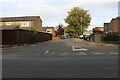
5

Kingscroft Court
1970s council houses in Bellinge, probably fair to say, one of the less salubrious suburbs of Northampton.
Image: © Burgess Von Thunen
Taken: 21 Oct 2013
0.20 miles