IMAGES TAKEN NEAR TO
Valley Road, NORTHAMPTON, NN3 9AL
Introduction
This page details the photographs taken nearby to Valley Road, NN3 9AL by members of the Geograph project.
The Geograph project started in 2005 with the aim of publishing, organising and preserving representative images for every square kilometre of Great Britain, Ireland and the Isle of Man.

There are currently over 7.5m images from over14,400 individuals and you can help contribute to the project by visiting https://www.geograph.org.uk
Image Map
Images are licensed for reuse under creativecommons.org/licenses/by-sa/2.0
Notes
- Clicking on the map will re-center to the selected point.
- The higher the marker number, the further away the image location is from the centre of the postcode.
Image Listing (6 Images Found)
Images are licensed for reuse under creativecommons.org/licenses/by-sa/2.0
Image
Details
Distance
1
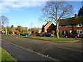
Orchard Hill
1950s council houses in Little Billing.
Image: © Burgess Von Thunen
Taken: 28 Dec 2013
0.14 miles
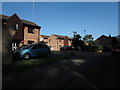
2
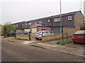
Campion Court
1980s council houses in Bellinge.
Image: © Burgess Von Thunen
Taken: 10 May 2016
0.16 miles
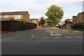
4
Whiteheart Close
1990s houses in Little Billing.
Image: © Burgess Von Thunen
Taken: 1 Jul 2014
0.23 miles
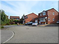
6
Sunset Court
1980s detached houses in Little Billing.
Image: © Burgess Von Thunen
Taken: 6 Aug 2014
0.25 miles