IMAGES TAKEN NEAR TO
Stonecircle Road, NORTHAMPTON, NN3 8RF
Introduction
This page details the photographs taken nearby to Stonecircle Road, NN3 8RF by members of the Geograph project.
The Geograph project started in 2005 with the aim of publishing, organising and preserving representative images for every square kilometre of Great Britain, Ireland and the Isle of Man.

There are currently over 7.5m images from over14,400 individuals and you can help contribute to the project by visiting https://www.geograph.org.uk
Image Map
Images are licensed for reuse under creativecommons.org/licenses/by-sa/2.0
Notes
- Clicking on the map will re-center to the selected point.
- The higher the marker number, the further away the image location is from the centre of the postcode.
Image Listing (4 Images Found)
Images are licensed for reuse under creativecommons.org/licenses/by-sa/2.0
Image
Details
Distance
1
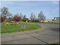
Round Spinney
Industrial estate at the corner of South Portway Close and Stone Circle Road.
Image: © Burgess Von Thunen
Taken: 14 Apr 2012
0.03 miles
2
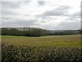
Coleman Leys
Part of the Round Spinney Industrial Estate can be seen behind the trees. Taken from the road running north-west to the A43 near Moulton.
Image: © Kokai
Taken: 12 Apr 2006
0.17 miles
4
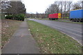
Trailers in Round Spinney industrial estate
Image: © Philip Jeffrey
Taken: 30 Jan 2022
0.23 miles