IMAGES TAKEN NEAR TO
Hangerfield Court, NORTHAMPTON, NN3 8LL
Introduction
This page details the photographs taken nearby to Hangerfield Court, NN3 8LL by members of the Geograph project.
The Geograph project started in 2005 with the aim of publishing, organising and preserving representative images for every square kilometre of Great Britain, Ireland and the Isle of Man.

There are currently over 7.5m images from over14,400 individuals and you can help contribute to the project by visiting https://www.geograph.org.uk
Image Map (Loading...)


Getting Data...Please wait
Leaflet Map data © OpenStreetMap
Images are licensed for reuse under creativecommons.org/licenses/by-sa/2.0
Notes
- Clicking on the map will re-center to the selected point.
- The higher the marker number, the further away the image location is from the centre of the postcode.
Image Listing (8 Images Found)
Images are licensed for reuse under creativecommons.org/licenses/by-sa/2.0
Image
Details
Distance
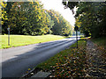
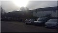
2
Billing Brook Road
Speed bumps in Lings.
Image: © Burgess Von Thunen
Taken: 14 Apr 2012
0.16 miles
3
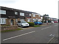
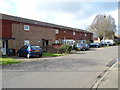
East Paddock Court
1970s council houses in Lings.
Image: © Burgess Von Thunen
Taken: 27 Feb 2014
0.17 miles
4
Tyes Court
1970s council houses in Lings.
Image: © Burgess Von Thunen
Taken: 26 Feb 2014
0.17 miles
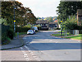
5
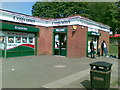
Costcutter, Billing Brook Road, Northampton
Image: © Alex McGregor
Taken: 2 Sep 2010
0.19 miles
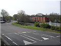
6
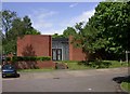
Brookside Community Centre
At Brookside Shopping Centre.
Image: © Kokai
Taken: 23 May 2006
0.20 miles
7
Flaxlands Court
1070s council houses in Lings.
Image: © Burgess Von Thunen
Taken: 18 Jan 2019
0.23 miles