IMAGES TAKEN NEAR TO
Harefield Road, NORTHAMPTON, NN3 8ER
Introduction
This page details the photographs taken nearby to Harefield Road, NN3 8ER by members of the Geograph project.
The Geograph project started in 2005 with the aim of publishing, organising and preserving representative images for every square kilometre of Great Britain, Ireland and the Isle of Man.

There are currently over 7.5m images from over14,400 individuals and you can help contribute to the project by visiting https://www.geograph.org.uk
Image Map
Images are licensed for reuse under creativecommons.org/licenses/by-sa/2.0
Notes
- Clicking on the map will re-center to the selected point.
- The higher the marker number, the further away the image location is from the centre of the postcode.
Image Listing (8 Images Found)
Images are licensed for reuse under creativecommons.org/licenses/by-sa/2.0
Image
Details
Distance
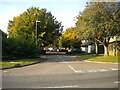
1
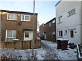
Pikemead Court
1970s council houses in Blackthorn.
Image: © Burgess Von Thunen
Taken: 30 Jan 2015
0.13 miles
2
Dore Close
1980s houses in Blackthorn.
Image: © Burgess Von Thunen
Taken: 15 Sep 2015
0.15 miles
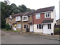
3
Shelford Close
1980s houses in The Glades.
Image: © Burgess Von Thunen
Taken: 29 Sep 2015
0.19 miles
4
Greatmeadow Road, Blackthorn
Off Blackthorn Road.
Image: © Richard Vince
Taken: 9 Oct 2021
0.22 miles
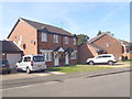
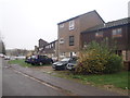
5
Collmead Court, Blackthorn
A residential cul de sac off Blackthorn Road.
Image: © Richard Vince
Taken: 9 Oct 2021
0.22 miles
6
Dryleys Court
1970s council houses in Goldings.
Image: © Burgess Von Thunen
Taken: 17 Nov 2015
0.24 miles
7
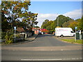
Blackthorn Bridge Court, Blackthorn
Off Blackthorn Road, providing vehicular access to the local retail centre.
Image: © Richard Vince
Taken: 9 Oct 2021
0.24 miles
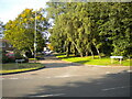
8
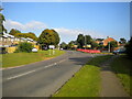
Blackthorn Road, Blackthorn
The main distributor road through the estate, approaching the junction with
Cherry Lodge Road.
Image: © Richard Vince
Taken: 9 Oct 2021
0.25 miles