IMAGES TAKEN NEAR TO
Northampton Lane North, NORTHAMPTON, NN3 7RF
Introduction
This page details the photographs taken nearby to Northampton Lane North, NN3 7RF by members of the Geograph project.
The Geograph project started in 2005 with the aim of publishing, organising and preserving representative images for every square kilometre of Great Britain, Ireland and the Isle of Man.

There are currently over 7.5m images from over14,400 individuals and you can help contribute to the project by visiting https://www.geograph.org.uk
Image Map (Loading...)


Getting Data...Please wait
Leaflet Map data © OpenStreetMap
Images are licensed for reuse under creativecommons.org/licenses/by-sa/2.0
Notes
- Clicking on the map will re-center to the selected point.
- The higher the marker number, the further away the image location is from the centre of the postcode.
Image Listing (7 Images Found)
Images are licensed for reuse under creativecommons.org/licenses/by-sa/2.0
Image
Details
Distance
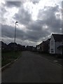
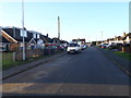
1
Northampton Lane North
1930s council houses in Moulton.
Image: © Burgess Von Thunen
Taken: 21 Jan 2014
0.01 miles
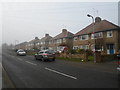
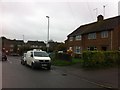
2
Brick and Pebbledash
These houses on the road into Moulton have a 1920s look to them but have clearly been refurbished at some time. Difficult to be sure but the upper floor may well be single skin brick.
Image: © Michael Patterson
Taken: 15 Dec 2006
0.08 miles
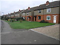
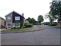
3
Horsewell Court
1970s semis in Moulton Leys.
Image: © Burgess Von Thunen
Taken: 16 Oct 2013
0.09 miles
4
Fuller Road
1950s houses in Moulton.
Image: © Burgess Von Thunen
Taken: 23 Dec 2015
0.13 miles
5
North Leys Court
1970s houses in Moulton Leys.
Image: © Burgess Von Thunen
Taken: 12 Jun 2015
0.15 miles
6
Fuller Road
1950s council houses in Moulton.
Image: © Burgess Von Thunen
Taken: 5 Nov 2015
0.15 miles