IMAGES TAKEN NEAR TO
Brunting Road, NORTHAMPTON, NN3 7QX
Introduction
This page details the photographs taken nearby to Brunting Road, NN3 7QX by members of the Geograph project.
The Geograph project started in 2005 with the aim of publishing, organising and preserving representative images for every square kilometre of Great Britain, Ireland and the Isle of Man.

There are currently over 7.5m images from over14,400 individuals and you can help contribute to the project by visiting https://www.geograph.org.uk
Image Map
Images are licensed for reuse under creativecommons.org/licenses/by-sa/2.0
Notes
- Clicking on the map will re-center to the selected point.
- The higher the marker number, the further away the image location is from the centre of the postcode.
Image Listing (16 Images Found)
Images are licensed for reuse under creativecommons.org/licenses/by-sa/2.0
Image
Details
Distance
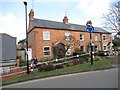
1
Fuller Road
1950s council houses in Moulton.
Image: © Burgess Von Thunen
Taken: 5 Nov 2015
0.07 miles
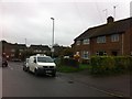
2
Fuller Road
1950s houses in Moulton.
Image: © Burgess Von Thunen
Taken: 23 Dec 2015
0.14 miles
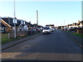
4
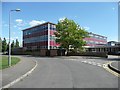
Part of Moulton College, Pound Lane
Image: © Humphrey Bolton
Taken: 24 Aug 2011
0.17 miles
6
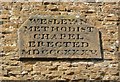
Datestone on the Village Theatre, Moulton
This shows that the building was erected as a Wesleyan Methodist chapel in 1835.
Image: © Humphrey Bolton
Taken: 24 Aug 2011
0.19 miles
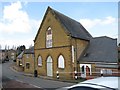
7
The Village Theatre, Moulton
The datestone Image shows that it was erected as a Wesleyan Methodist chapel in 1835. It is in the simple Gothic style of the early 19C.
Image: © Humphrey Bolton
Taken: 24 Aug 2011
0.19 miles
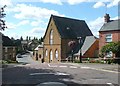
8
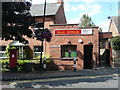
The Post Office, Cross Street, Moulton
Image: © Humphrey Bolton
Taken: 24 Aug 2011
0.19 miles
9
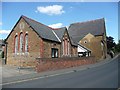
Former school, Cross Street, Moulton
Image: © Humphrey Bolton
Taken: 24 Aug 2011
0.19 miles