IMAGES TAKEN NEAR TO
Stanton Close, NORTHAMPTON, NN3 7BZ
Introduction
This page details the photographs taken nearby to Stanton Close, NN3 7BZ by members of the Geograph project.
The Geograph project started in 2005 with the aim of publishing, organising and preserving representative images for every square kilometre of Great Britain, Ireland and the Isle of Man.

There are currently over 7.5m images from over14,400 individuals and you can help contribute to the project by visiting https://www.geograph.org.uk
Image Map
Images are licensed for reuse under creativecommons.org/licenses/by-sa/2.0
Notes
- Clicking on the map will re-center to the selected point.
- The higher the marker number, the further away the image location is from the centre of the postcode.
Image Listing (11 Images Found)
Images are licensed for reuse under creativecommons.org/licenses/by-sa/2.0
Image
Details
Distance
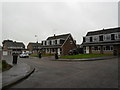
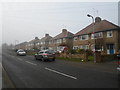
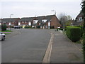
1

Cottingham Drive
1970s houses in Moulton.
Image: © Burgess Von Thunen
Taken: 29 Jun 2014
0.13 miles
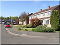
2
Horsewell Court
1970s semis in Moulton Leys.
Image: © Burgess Von Thunen
Taken: 16 Oct 2013
0.15 miles
3
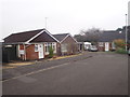
Oundle Drive
1970s bungalows in Moulton.
Image: © Burgess Von Thunen
Taken: 17 Nov 2015
0.16 miles
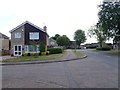
4
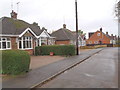
Northampton Lane South
1950s bungalows in Moulton.
Image: © Burgess Von Thunen
Taken: 29 Oct 2015
0.17 miles
5
Cedar Gate
2000s flats in Moulton Leys.
Image: © Burgess Von Thunen
Taken: 13 Oct 2015
0.17 miles
6
Oundle Drive
1070s houses in Moulton.
Image: © Burgess Von Thunen
Taken: 4 Mar 2014
0.18 miles
7
Rutland Walk
1070s houses in Moulton.
Image: © Burgess Von Thunen
Taken: 17 May 2016
0.19 miles
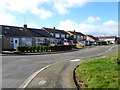
8
Northampton Lane North
1930s council houses in Moulton.
Image: © Burgess Von Thunen
Taken: 21 Jan 2014
0.20 miles
9
North Leys Court
1970s houses in Moulton Leys.
Image: © Burgess Von Thunen
Taken: 12 Jun 2015
0.22 miles
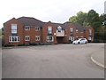
10
Cottingham Drive
The houses on Cottingham Drive in Moulton Park have a late 70s early 80s look to them.
Image: © Michael Patterson
Taken: 15 Dec 2006
0.22 miles