IMAGES TAKEN NEAR TO
Reedings, NORTHAMPTON, NN3 7AX
Introduction
This page details the photographs taken nearby to Reedings, NN3 7AX by members of the Geograph project.
The Geograph project started in 2005 with the aim of publishing, organising and preserving representative images for every square kilometre of Great Britain, Ireland and the Isle of Man.

There are currently over 7.5m images from over14,400 individuals and you can help contribute to the project by visiting https://www.geograph.org.uk
Image Map (Loading...)


Getting Data...Please wait
Leaflet Map data © OpenStreetMap
Images are licensed for reuse under creativecommons.org/licenses/by-sa/2.0
Notes
- Clicking on the map will re-center to the selected point.
- The higher the marker number, the further away the image location is from the centre of the postcode.
Image Listing (5 Images Found)
Images are licensed for reuse under creativecommons.org/licenses/by-sa/2.0
Image
Details
Distance
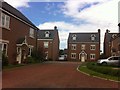
1
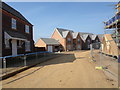
Countess Manor
A new development on the edge of Moulton.
Image: © Burgess Von Thunen
Taken: 14 Mar 2014
0.09 miles
2
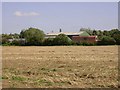
Sandy Hill Farm
Taken from a footpath that runs through a field belonging to Grove Farm.
Image: © Kokai
Taken: 6 Sep 2006
0.10 miles
3
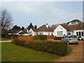
Overstone Road
1930s bungalows in Moulton.
Image: © Burgess Von Thunen
Taken: 27 Mar 2014
0.11 miles
4
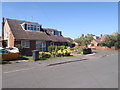
Tarrant Way
1970s semis in Moulton.
Image: © Burgess Von Thunen
Taken: 12 Aug 2015
0.11 miles
5
Inniskilling Close
2000s houses in Moulton.
Image: © Burgess Von Thunen
Taken: 1 Jun 2013
0.22 miles