IMAGES TAKEN NEAR TO
Kings Park Road, NORTHAMPTON, NN3 6LL
Introduction
This page details the photographs taken nearby to Kings Park Road, NN3 6LL by members of the Geograph project.
The Geograph project started in 2005 with the aim of publishing, organising and preserving representative images for every square kilometre of Great Britain, Ireland and the Isle of Man.

There are currently over 7.5m images from over14,400 individuals and you can help contribute to the project by visiting https://www.geograph.org.uk
Image Map
Images are licensed for reuse under creativecommons.org/licenses/by-sa/2.0
Notes
- Clicking on the map will re-center to the selected point.
- The higher the marker number, the further away the image location is from the centre of the postcode.
Image Listing (3 Images Found)
Images are licensed for reuse under creativecommons.org/licenses/by-sa/2.0
Image
Details
Distance
1
Northampton Science Park
Caxton House.
Image: © Burgess Von Thunen
Taken: 2 Aug 2011
0.11 miles
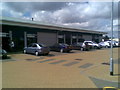
2

King's Park Road at Moulton Park industrial estate
Image: © Roger Davies
Taken: 7 Oct 2009
0.12 miles
3
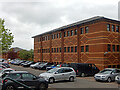
Francis Crick House, Moulton Park
Francis Crick House is one of the office blocks that form Moulton Park, an extensive business park on the edge of Northampton. It was built in the early 1990s and refurbished in 2008; much of it is used by the NHS. Francis Crick, best known for his work in 1953 which led to the identification of the 'double helix' structure of DNA, was born in Northampton. Most of the cars seen here in the car park on the west side of the building were here for the Covid-19 vaccination centre located in the building in the background.
Image: © Stephen McKay
Taken: 20 May 2021
0.20 miles