IMAGES TAKEN NEAR TO
Deansway, NORTHAMPTON, NN3 5JY
Introduction
This page details the photographs taken nearby to Deansway, NN3 5JY by members of the Geograph project.
The Geograph project started in 2005 with the aim of publishing, organising and preserving representative images for every square kilometre of Great Britain, Ireland and the Isle of Man.

There are currently over 7.5m images from over14,400 individuals and you can help contribute to the project by visiting https://www.geograph.org.uk
Image Map
Images are licensed for reuse under creativecommons.org/licenses/by-sa/2.0
Notes
- Clicking on the map will re-center to the selected point.
- The higher the marker number, the further away the image location is from the centre of the postcode.
Image Listing (10 Images Found)
Images are licensed for reuse under creativecommons.org/licenses/by-sa/2.0
Image
Details
Distance
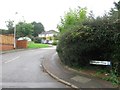
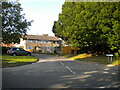
1
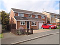
Deansway
1980s semis in Rectory Farm.
Image: © Burgess Von Thunen
Taken: 2 Oct 2015
0.02 miles
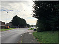
2
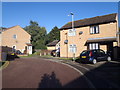
Morgan Close
1980s semis in Rectory Farm.
Image: © Burgess Von Thunen
Taken: 24 Sep 2015
0.07 miles
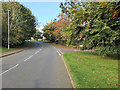
3
Daimler Close
1980s detached houses in Rectory Farm.
Image: © Burgess Von Thunen
Taken: 18 Jan 2019
0.09 miles
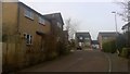
8
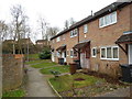
Ermine Road
1970s council houses in Rectory Farm.
Image: © Burgess Von Thunen
Taken: 6 Mar 2014
0.19 miles
9
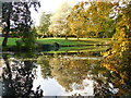
Rectory Farm Pocket Park
Rectory Farm Pocket Park in Great Billing, Northampton, Northamptonshire, UK.
Image: © Nathan Hadley
Taken: 25 Oct 2020
0.20 miles
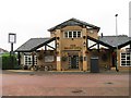
10
Greatmeadow, Blackthorn
Off Blackthorn Road.
Image: © Richard Vince
Taken: 9 Oct 2021
0.24 miles