IMAGES TAKEN NEAR TO
Ecton Brook Road, NORTHAMPTON, NN3 5EN
Introduction
This page details the photographs taken nearby to Ecton Brook Road, NN3 5EN by members of the Geograph project.
The Geograph project started in 2005 with the aim of publishing, organising and preserving representative images for every square kilometre of Great Britain, Ireland and the Isle of Man.

There are currently over 7.5m images from over14,400 individuals and you can help contribute to the project by visiting https://www.geograph.org.uk
Image Map
Images are licensed for reuse under creativecommons.org/licenses/by-sa/2.0
Notes
- Clicking on the map will re-center to the selected point.
- The higher the marker number, the further away the image location is from the centre of the postcode.
Image Listing (13 Images Found)
Images are licensed for reuse under creativecommons.org/licenses/by-sa/2.0
Image
Details
Distance
1
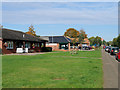
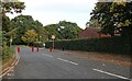
Medical Centre and Pharmacy on Ecton Brook Road
Image: © David Dixon
Taken: 23 Oct 2019
0.01 miles
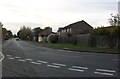
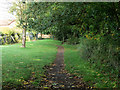
4
The end of Ecton Brook Road, Great Billing
The Brook is at the end.
Image: © David Howard
Taken: 9 Oct 2022
0.10 miles
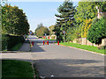
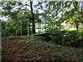
6

Ecton Brook Linear Park
This is the beginning of the park at the south end. The brook, behind the shrubs and trees to the right, is a Constituency and Parish boundary.
Image: © Kokai
Taken: 16 May 2006
0.13 miles
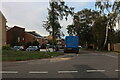
9
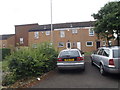
Thurspit Place
1970s council houses in Ecton Brook.
Image: © Burgess Von Thunen
Taken: 15 Jul 2015
0.17 miles