IMAGES TAKEN NEAR TO
Tavistock Close, NORTHAMPTON, NN3 5DQ
Introduction
This page details the photographs taken nearby to Tavistock Close, NN3 5DQ by members of the Geograph project.
The Geograph project started in 2005 with the aim of publishing, organising and preserving representative images for every square kilometre of Great Britain, Ireland and the Isle of Man.

There are currently over 7.5m images from over14,400 individuals and you can help contribute to the project by visiting https://www.geograph.org.uk
Image Map (Loading...)


Getting Data...Please wait
Leaflet Map data © OpenStreetMap
Images are licensed for reuse under creativecommons.org/licenses/by-sa/2.0
Notes
- Clicking on the map will re-center to the selected point.
- The higher the marker number, the further away the image location is from the centre of the postcode.
Image Listing (19 Images Found)
Images are licensed for reuse under creativecommons.org/licenses/by-sa/2.0
Image
Details
Distance
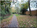
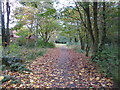
3
Ridgewalk
Heading under Ecton Brook Road.
Image: © Burgess Von Thunen
Taken: 1 Nov 2013
0.14 miles
5
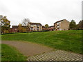
Blueberry Rise
Open space and council properties in Ecton Brook.
Image: © Burgess Von Thunen
Taken: 1 Nov 2013
0.15 miles
7
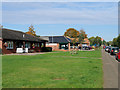
Medical Centre and Pharmacy on Ecton Brook Road
Image: © David Dixon
Taken: 23 Oct 2019
0.17 miles
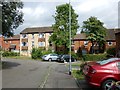
8
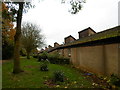
Blueberry Rise
The rear of bungalows in Ecton Brook. The Frankenstein-like protuberances on the roofs I guess must contain water tanks.
Image: © Burgess Von Thunen
Taken: 1 Nov 2013
0.20 miles
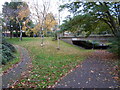
9
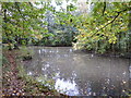
Ecton Brook Linear Park
A murky old pond.
Image: © Burgess Von Thunen
Taken: 1 Nov 2013
0.20 miles
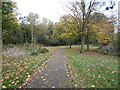
10
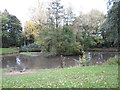
Ecton Brook Linear Park
An island in a pond on the edge of town.
Image: © Burgess Von Thunen
Taken: 1 Nov 2013
0.20 miles