IMAGES TAKEN NEAR TO
St. Gregorys Road, NORTHAMPTON, NN3 3RF
Introduction
This page details the photographs taken nearby to St. Gregorys Road, NN3 3RF by members of the Geograph project.
The Geograph project started in 2005 with the aim of publishing, organising and preserving representative images for every square kilometre of Great Britain, Ireland and the Isle of Man.

There are currently over 7.5m images from over14,400 individuals and you can help contribute to the project by visiting https://www.geograph.org.uk
Image Map (Loading...)


Getting Data...Please wait
Leaflet Map data © OpenStreetMap
Images are licensed for reuse under creativecommons.org/licenses/by-sa/2.0
Notes
- Clicking on the map will re-center to the selected point.
- The higher the marker number, the further away the image location is from the centre of the postcode.
Image Listing (7 Images Found)
Images are licensed for reuse under creativecommons.org/licenses/by-sa/2.0
Image
Details
Distance
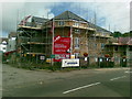
1
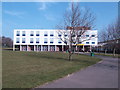
Northampton College
A further education establishment set in a campus to the east of the town centre.
Image: © Jonathan Billinger
Taken: 5 Apr 2007
0.02 miles
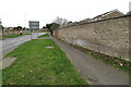
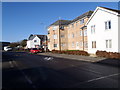
3
New Flats, Gregory Gardens, Boothville
Image: © Alex McGregor
Taken: 7 Sep 2010
0.09 miles
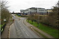
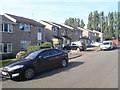
4
Grange Road
2010s flats in Eastfield.
Image: © Burgess Von Thunen
Taken: 16 Feb 2016
0.10 miles
5
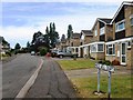
Esher Court
1980s semis in The Arbours.
Image: © Burgess Von Thunen
Taken: 12 Aug 2015
0.19 miles