IMAGES TAKEN NEAR TO
Priory Close, NORTHAMPTON, NN3 3LQ
Introduction
This page details the photographs taken nearby to Priory Close, NN3 3LQ by members of the Geograph project.
The Geograph project started in 2005 with the aim of publishing, organising and preserving representative images for every square kilometre of Great Britain, Ireland and the Isle of Man.

There are currently over 7.5m images from over14,400 individuals and you can help contribute to the project by visiting https://www.geograph.org.uk
Image Map
Images are licensed for reuse under creativecommons.org/licenses/by-sa/2.0
Notes
- Clicking on the map will re-center to the selected point.
- The higher the marker number, the further away the image location is from the centre of the postcode.
Image Listing (19 Images Found)
Images are licensed for reuse under creativecommons.org/licenses/by-sa/2.0
Image
Details
Distance
1
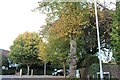
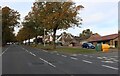
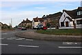
Rushmere Road at the junction of Billing Road East
Image: © David Howard
Taken: 9 Oct 2022
0.09 miles
2
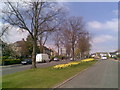
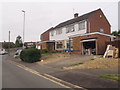
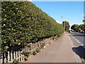
Rushmere Road
Taken from a service road, showing 1950s semis.
Image: © Burgess Von Thunen
Taken: 14 Apr 2010
0.10 miles
3
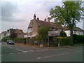
Rushmere Road
At the junction with Rushmere Avenue.
Image: © Burgess Von Thunen
Taken: 5 May 2010
0.11 miles
4
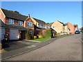
Primula Close
1990s house in Abington Vale.
Image: © Burgess Von Thunen
Taken: 26 Feb 2014
0.12 miles
6
Parracombe Way
1960s semis in Abington Vale.
Image: © Burgess Von Thunen
Taken: 21 Sep 2015
0.19 miles
7
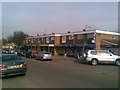
Landcross Drive
Local shops in Abington Vale.
Image: © Burgess Von Thunen
Taken: 5 Mar 2010
0.19 miles
8
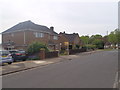
Watersmeet
1950s houses in Rushmere.
Image: © Burgess Von Thunen
Taken: 8 May 2015
0.19 miles
10
Watersmeet at the junction of Rushmere Road
The waters are the River Nene running nearby.
Image: © David Howard
Taken: 9 Oct 2022
0.20 miles